Просмотр новости
Найдите то, что Вас интересует
 Спутники
 РН
РН SpaceX
 Роскосмос
 NASA
NASA
СпутникиРНSpaceXРоскосмосNASABackground Remote sensing for forest monitoring has expanded substantially over the past four decades, driven by advances in Earth observation, geospatial analytics, and artificial intelligence. Despite this rapid growth, the literature remains fragmented across diverse themes, methods, and disciplinary domains, limiting a comprehensive understanding of its long-term evolution. Unlike previous bibliometric studies that have focused on specific technologies or applications, this study provides an integrated assessment of the field’s intellectual foundations, collaboration patterns, thematic dynamics, and emerging research frontiers over a period of four and a half decades. Methods A bibliometric and science-mapping approach was applied to Scopus-indexed publications published between 1980 and 2025. Performance analysis was combined with co-authorship, co-citation, and keyword co-occurrence techniques to examine scientific productivity, collaboration networks, intellectual foundations, and thematic developments. Results Scientific output has increased steadily, accompanied by interconnected citation networks and expanding international collaboration. Scholarly activity is concentrated among influential authors, institutions, and countries, with North America, Western Europe, and East Asia serving as centers of knowledge production. Five domains shape the intellectual landscape: land-cover dynamics, LiDAR-based assessment, Earth observation analytics, forest inventory modeling, and ecosystem disturbance studies. Thematic trajectories indicate a transition from descriptive land-cover analysis to predictive, data-intensive approaches driven by machine learning, deep learning, cloud computing, multi-sensor integration, and observations. Linkages between forest monitoring, carbon accounting, climate adaptation, and environmental governance highlight the growing societal relevance of the field. Emerging research frontiers include foundation models, explainable artificial intelligence, digital-twin forest ecosystems, near-real-time monitoring, and climate-smart forest governance.
Forests constitute a critical component of the Earth system, playing essential roles in carbon sequestration, biodiversity conservation, hydrological regulation, and the provision of ecosystem services that support environmental sustainability and human well-being (Meyfroidt, 2012; Jahanifar et al., 2017; Shembo et al., 2025). However, forest ecosystems are increasingly threatened by land-use conversion, agricultural expansion, infrastructure development, natural resource exploitation, and climate change (Muhati, Olago and Olaka, 2018; Kamińska et al., 2026; Gao, Xiang and Liu, 2026). According to FAO (2020), more than 420 million hectares of forest have been lost worldwide since 1990, with tropical regions remaining the principal hotspots of global deforestation. These pressures are further intensified by the increasing occurrence of forest fires, forest degradation, and other ecological disturbances that diminish forest ecosystem functions and accelerate global environmental change. Consequently, the availability of accurate, consistent, and timely monitoring systems has become increasingly important for supporting forest management, biodiversity conservation, climate-change mitigation, and evidence-based decision-making (Slagter et al., 2024; Yadegari et al., 2025; Zhidebayeva et al., 2025; D’Amico et al., 2026).
Advances in remote sensing technologies have transformed forest monitoring by enabling the generation of increasingly detailed, continuous, and multi-scale information. The Landsat archive has facilitated long-term forest-change analyses through consistent Earth observation records spanning more than four decades (Rose and Nagle, 2021; Jutras-Perreault, Gobakken and Ørka, 2021; Tigabu and Gessesse, 2025). Meanwhile, Sentinel-1 and Sentinel-2 have enhanced monitoring capabilities through higher spatial resolution, improved temporal frequency, and broad geographical coverage (Bontemps et al., 2015; Donezar-Hoyos et al., 2017; Ullmann et al., 2019). Furthermore, the integration of LiDAR, Synthetic Aperture Radar (SAR), uncrewed aerial vehicles (UAVs), cloud computing, machine learning, and deep learning has substantially strengthened the capacity to identify, characterize, and model forest attributes from Earth observation data (Zhidebayeva et al., 2025). These developments have repositioned remote sensing from a tool primarily used for land-cover mapping to an analytical foundation for understanding ecosystem dynamics and supporting data-driven forest management.
Despite significant technological advances, many global forest-monitoring systems continue to produce inconsistent estimates of forest change (Gao et al., 2020). Such discrepancies arise from differences in the definitions of forest loss and forest degradation, variations in classification algorithms, heterogeneity among data sources, and the absence of standardized validation procedures (Herold et al., 2011; Mitchell, Rosenqvist and Mora, 2017; Neeff et al., 2024). As a result, uncertainty remains a major challenge in carbon-emission reporting, the evaluation of REDD+ programs, and the monitoring of global climate targets. This situation suggests that improving the reliability of forest monitoring depends not only on technological innovation but also on strengthening and integrating the scientific knowledge that underpins methodological development, data generation, and the interpretation of results.
In parallel with the growing demand for accurate forest information to support climate-change mitigation, biodiversity conservation, and sustainable natural-resource management, remote sensing for forest monitoring has emerged as an increasingly strategic research domain. Remote-sensing technologies are now applied across a wide range of activities, including deforestation detection, forest inventory assessment, biomass and carbon-stock estimation, wildfire-risk modeling, and climate-change impact analysis (Calders et al., 2020; Peña-Villacreses et al., 2024; Prodromou et al., 2025; Yilmaz, 2026). The breadth of these applications reflects the growing integration of multiple disciplines to support data-driven decision-making in forest management and conservation.
From a Science of Science perspective, the maturity of a research field is reflected not only in the growth of publication output but also in the evolution of the knowledge structures formed through citation networks, collaboration patterns, and thematic developments (Chakraborty et al., 2015; Hosseini, Alipour-Tehrani and Salemi, 2025; Hussain et al., 2025). Scientific Development Theory views scientific progress as a process of knowledge accumulation, diffusion, and reorganization, whereas Knowledge Evolution Theory emphasizes that changes in intellectual structures reflect paradigm shifts, interdisciplinary integration, and the emergence of new research frontiers (Zhang et al., 2022; Michalska, 2023; Yang et al., 2024). Consequently, bibliometric and science-mapping approaches provide valuable instruments for identifying knowledge foundations, mapping intellectual development, and systematically examining the evolution of remote sensing for forest monitoring (Donthu et al., 2021).
Several bibliometric studies have investigated the development of remote sensing in forestry and environmental research. Mngadi et al. (2024) analyzed the application of remote-sensing technologies for mapping forest pests and diseases at the tree level; however, their study focused on a highly specific topic and therefore did not provide a comprehensive understanding of broader forest-monitoring research. Bełej (2024) examined remote-sensing studies related to land use, urban planning, environmental monitoring, and sustainability, but did not specifically address the evolution of forest-monitoring research. Likewise, Essbiti et al. (2025) reviewed remote-sensing techniques and platforms for sustainable forest-degradation monitoring, with a primary emphasis on methodological aspects, while largely overlooking the relationships among intellectual foundations, collaboration networks, and shifts in research priorities.
These limitations indicate that current understanding of remote sensing for forest monitoring remains fragmented. To date, studies integrating scientific productivity, intellectual structures, collaboration networks, thematic dynamics, and research frontiers within a single science-mapping framework spanning more than four decades remain scarce. Consequently, the transformation of the field from observational approaches focused on land-cover change detection towards analytical and predictive systems based on artificial intelligence, multi-sensor integration, and geospatial computing has not yet been comprehensively documented.
To address this gap, the present study offers three main contributions. First, it provides a comprehensive bibliometric mapping that integrates analyses of intellectual structures, scientific collaboration, thematic dynamics, and research frontiers over the period 1980–2025. Second, it combines performance analysis and science mapping to explain the interrelationships among advances in Earth observation technologies, the formation of scientific communities, and shifts in research priorities. Third, it adopts a knowledge-evolution perspective to elucidate how a scientific domain develops, transforms, and generates new research directions over time. Based on these objectives, the study aims to map and analyze the evolution of remote sensing for forest monitoring during 1980–2025 using a bibliometric and science-mapping approach based on internationally recognized scholarly publications. To address the identified research gap, the study is guided by the following research questions.
This study employed a bibliometric approach, combined with science mapping, to examine the development of remote sensing for forest monitoring, drawing on scientific publications and citation patterns. By applying co-citation, co-authorship, and keyword co-occurrence analyses, the study systematically mapped the intellectual foundations, collaboration networks, conceptual structures, thematic evolution, and emerging research frontiers of the field (Donthu et al., 2021; Permatasari et al., 2025). The identification and selection of the literature were guided by the Preferred Reporting Items for Systematic Reviews and Meta-Analyses (PRISMA) framework to ensure transparency, consistency, and reproducibility throughout all stages of the research process (Eschiti and Siaki, 2026). The data were retrieved from the Scopus database due to its broad multidisciplinary coverage, high-quality metadata, and reliable citation indexing, which make it particularly suitable for large-scale bibliometric analyses (Li et al., 2010).
The literature search was conducted using the following query: TITLE-ABS-KEY (“Remote Sensing” AND “Forest Monitoring”) AND PUBYEAR >1979 AND PUBYEAR <2026 AND (LIMIT-TO (SUBJAREA, “EART”) OR LIMIT-TO (SUBJAREA, “COMP”) OR LIMIT-TO (SUBJAREA, “ENVI”) OR LIMIT-TO (SUBJAREA, “AGRI”) OR LIMIT-TO (SUBJAREA, “ENGI”) OR LIMIT-TO (SUBJAREA, “SOCI”)) AND (LIMIT-TO (DOCTYPE, “ar”)) AND (LIMIT-TO (LANGUAGE, “English”)). The period 1980–2025 was selected to capture the transition from the era of early satellite observation systems to the adoption of multi-sensor technologies, cloud computing, and artificial intelligence (AI) in forest monitoring. The dataset comprised bibliographic metadata, including titles, abstracts, keywords, citation information, and other publication attributes, in accordance with the recommendations of Donthu et al. (2021). To ensure analytical consistency and reliability, only English-language journal articles indexed in Scopus were included in the study ( Figure 1).
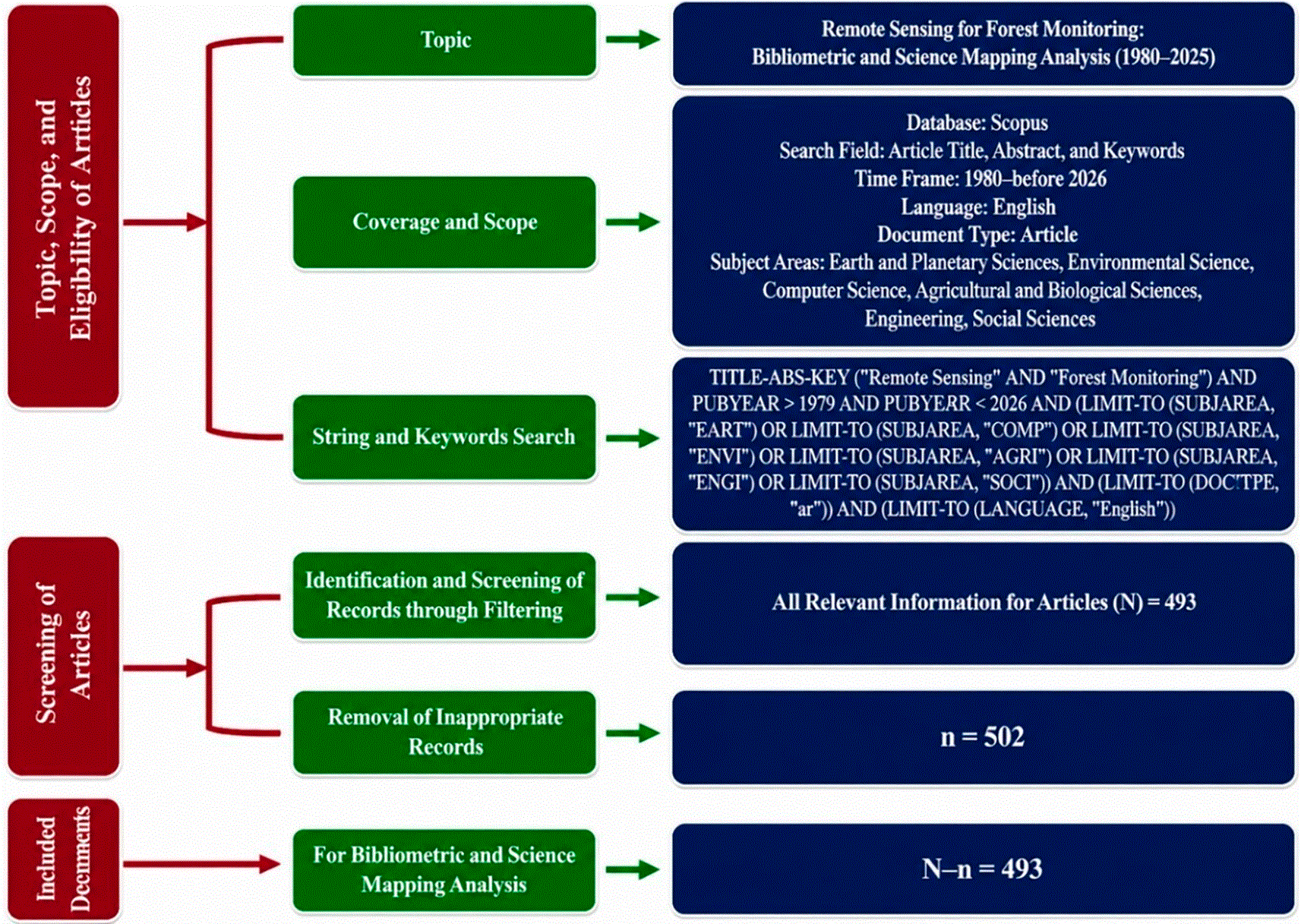
Flow diagram illustrating the literature selection process conducted according to the PRISMA 2020 guidelines. The diagram summarizes the identification, screening, eligibility assessment, and final inclusion of publications retrieved from the Scopus database for bibliometric and science mapping analyses.
The initial search identified 995 publications from the Scopus database. Following the PRISMA framework, the dataset was refined by restricting the subject areas to Earth and Planetary Sciences, Environmental Science, Computer Science, Agricultural and Biological Sciences, Engineering, and Social Sciences, resulting in 969 publications relevant to the research topic. A further restriction to journal research articles reduced the dataset to 529 publications, while language filtering yielded 493 English-language articles that met the inclusion criteria.
The final corpus consisted of peer-reviewed articles addressing the application of remote sensing in forest monitoring, including studies on deforestation, forest degradation, land-cover change, landscape fragmentation, biomass assessment, and ecosystem dynamics. Duplicate records, non-research documents, and non-English publications were excluded from the analysis. The final dataset of 493 articles formed the basis for evaluating scientific productivity, intellectual structures, collaboration networks, and thematic developments within the field.
The analysis was conducted using the Bibliometrix package in R (version 4.4.1) via the Biblioshiny interface, together with VOSviewer version 1.6.20 (Kumar, 2025). Metadata exported from Scopus in CSV format was imported and processed to generate bibliometric indicators, thematic analyses, and statistical visualizations (Donthu et al., 2021). The analytical framework integrated both performance analysis and science mapping techniques. Performance analysis was employed to evaluate publication productivity, citation impact, and the contributions of authors, institutions, and countries (Gutiérrez-Salcedo et al., 2018). In contrast, science mapping was used to identify intellectual structures, collaboration patterns, and conceptual configurations through co-authorship, co-citation, and keyword co-occurrence analyses (Budhiraja and Dhall, 2026). This integrated approach enabled a comprehensive assessment of the evolution, knowledge structure, and emerging directions of research in remote sensing for forest monitoring.
The bibliometric characteristics presented in Table 1 indicate that remote sensing for forest monitoring has evolved into a well-established and multidisciplinary research domain. The dataset comprises 493 publications published between 1980 and 2025 and distributed across 180 sources, reflecting the broad dissemination of knowledge and the involvement of diverse scientific disciplines. An annual growth rate of 10.87% demonstrates sustained expansion, consistent with the increasing availability of open-access satellite data, cloud computing platforms, and artificial intelligence-based analytical technologies. This transformation reflects a shift from conventional forest-mapping approaches towards more automated, predictive, and data-driven monitoring systems. These findings are consistent with those of Yang et al. (2025), who reported that the integration of AI, the Internet of Things (IoT), and machine learning has enhanced the precision, efficiency, and scalability of forest monitoring while strengthening its role in supporting climate-smart forestry and sustainable resource management.
The average publication age of 7.82 years suggests the predominance of relatively recent literature, whereas an average of 38.13 citations per document indicates a substantial scientific influence within the international research community. The accumulation of 58,913 references further reflects a broad and highly interconnected knowledge base. Collectively, these findings suggest that the field possesses a strong scientific foundation while maintaining the capacity to adapt to technological advances and the emergence of new research agendas.
The temporal distribution of publications reveals relatively slow growth during the early stages of the field, followed by a substantial increase after 2013, with the most pronounced acceleration occurring between 2017 and 2025 ( Figure 2). Scientific output peaked in 2025, with 104 published documents, reflecting growing scholarly interest in remote sensing-based forest monitoring. Advances in Earth observation technologies have driven this trend, along with the increasing availability of open-access satellite data and the rising demand for information to support climate-change mitigation and sustainable forest management (Gašparović et al., 2024).
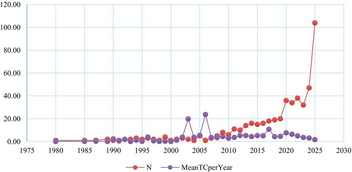
Annual publication output and average citation impact of the retrieved literature from 1980 to 2025. The figure illustrates the temporal growth of scientific production and citation dynamics within the field of remote sensing for forest monitoring.
Citation patterns exhibit a different dynamic from publication trends. High citation rates during the early period, particularly in 2003 and 2006 (19.83 and 23.71 citations per year, respectively), indicate the pivotal role of early studies in establishing the intellectual foundations of the field. Between 2017 and 2022, citation levels remained moderate to high, suggesting that research produced during this period continued to make substantial contributions to knowledge development. The decline in citation rates observed in 2024 and 2025 (3.07 and 1.71, respectively) is more likely attributable to the citation-lag effect, as recently published studies have not yet had sufficient time to accumulate citations within the scholarly network. Overall, the combination of increasing scientific output and sustained citation influence demonstrates that the field has not only expanded quantitatively but has also maintained its scientific relevance and impact within the global research community (Pérez-Campdesuñer et al., 2025).
Scientific productivity analysis was conducted to identify the principal actors contributing to the development of remote sensing for forest monitoring at the author, institutional, and national levels. The results presented in Table 2 indicate that scientific production within this field is concentrated among a relatively small number of authors, institutions, and countries that serve as key drivers of its advancement. This pattern reflects a core–periphery structure, whereby a substantial proportion of scientific output is generated by research groups possessing strong research capacity, extensive resources, and well-established collaboration networks.
At the author level, Herold (Germany) and Wulder (Canada) were the most productive contributors, each publishing 12 articles (2.4%), followed by Chirici (Italy) with 11 publications (2.2%). Francini produced 9 publications (1.8%), while White contributed 8 publications (1.6%). Hansen and Silva (United States) each authored 7 publications (1.4% of the total). Hermosilla, Guerra-Hernández, and Li completed the group of leading contributors, with 6 publications (1.2%) each. This concentration of scholarly contributions highlights the influential role of a relatively small group of researchers in shaping research agendas and advancing methodological innovation within the field.
At the institutional level, the University of Maryland ranked first with 30 articles (1.3%), followed by Wageningen University & Research with 28 articles (1.2%) and the University of Florence with 27 articles (1.2%). The Canadian Forest Service and University of Eastern Finland each produced 23 articles (1.0%), while Fujian Agriculture and Forestry University contributed 22 articles (1.0%). The presence of institutions from North America, Europe, and Asia demonstrates that a broad organizational network supports research activity. However, the largest contributions continue to come from institutions with well-developed geospatial infrastructure and established research capacity.
At the national level, China ranked first with 361 occurrences (13.6%), followed by the United States with 348 occurrences (13.1%). Italy recorded 231 occurrences (8.7%), while Germany, the United Kingdom, Canada, Finland, France, and the Netherlands formed the next tier of major contributors. This pattern demonstrates the dominance of countries that have made substantial investments in environmental research, Earth observation technologies, and geospatial data development.
The leadership of researchers such as Herold, Wulder, and Chirici highlights the strong influence of research centers in Western Europe and North America in establishing the methodological foundations of forest monitoring. At the same time, the growing contribution of China reflects a broader transformation in the global scientific landscape, driven by substantial investments in Earth observation technologies, artificial intelligence, and geospatial data infrastructure. These developments suggest a gradual shift towards a more multipolar configuration of knowledge production. Nevertheless, traditional research hubs continue to occupy strategic positions within international scientific networks owing to their established research capacities, extensive collaboration networks, and accumulated academic influence developed over several decades (Danell, 2025).
Citation network mapping using VOSviewer revealed that the literature on remote sensing for forest monitoring is organized into five major, interconnected clusters ( Figure 3 and Table 3). This configuration indicates that the contributions of distinct yet complementary scientific communities have shaped the development of the field. From a science-mapping perspective, citation patterns reflect the accumulation of knowledge that forms the intellectual foundation of a research domain and illustrate how ideas, methods, and approaches evolve (Zhang, Liu and Xia, 2025).
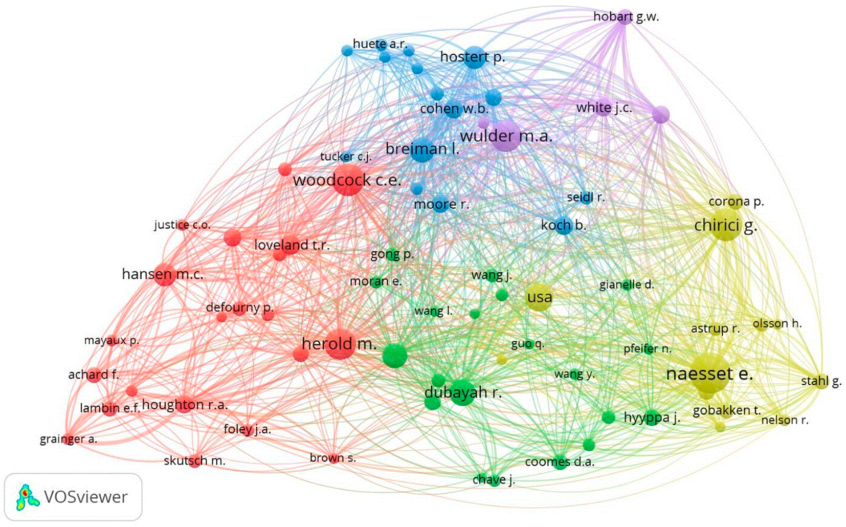
Citation network of influential authors generated using VOSviewer. Node size represents citation impact, while link thickness indicates the strength of citation relationships between authors. Colors represent clusters identified through network analysis.
The first cluster is centered on land-cover change and global forest observation, with key contributions from Herold, Hansen, Woodcock, Loveland, Houghton, and Defourny, whose work has provided the foundation for understanding deforestation dynamics and landscape change. The second cluster is built around LiDAR technologies through the contributions of Dubayah, Wang, Guo, Coomes, and Asner, whose studies have expanded analytical capabilities towards forest structural characterization, biomass estimation, and carbon accounting. The third cluster links remote sensing with statistical approaches and time-series analysis through the work of Wulder, Hostert, Breiman, Cohen, and Moore. In contrast, the fourth cluster is dominated by research on airborne laser scanning (ALS) and forest inventory applications led by Næsset, Chirici, Corona, Ståhl, and Gobakken.
The fifth cluster broadens the scope of research to encompass ecosystem disturbances and forest responses to environmental change through the contributions of White, Hobart, Seidl, Koch, and Olsson. The presence of these five clusters demonstrates a clear differentiation of roles within the scientific community, ranging from the establishment of conceptual foundations and the development of measurement techniques to the integration of quantitative analyses and the application of research to increasingly complex environmental challenges. The interconnections among clusters indicate that the interaction of spatial observation, biophysical measurement, quantitative modeling, and ecological-process understanding has driven advances in the field.
The positions actors occupy within the citation network provide more meaningful insights than citation counts alone. Wulder and Hostert function as important bridges between observational and analytical approaches, while Næsset and Chirici serve as key references in the development of forest-inventory methodologies. Dubayah and Asner have broadened the scope of the field of applying LiDAR technologies to biomass and carbon analysis. These findings suggest that scientific influence is determined not only by scholarly productivity but also by the ability to connect different research areas and stimulate the emergence of new research directions. The resulting citation structure reflects a mature research field characterized by strong intellectual foundations, broad methodological diversity, and increasingly intensive thematic integration (Ogawa and Kajikawa, 2017; Yu et al., 2023).
Co-authorship network mapping using VOSviewer revealed that collaboration in remote sensing for forest monitoring is organized into three major interconnected clusters ( Figure 4 and Table 4). This structure indicates that knowledge production within the field evolves through well-organized collaborative networks, in which certain research groups function as centers of methodological development. In contrast, others contribute primarily through empirical research and by linking different scientific communities. Such a pattern reflects the characteristics of a mature research field, where scientific progress is no longer driven by isolated individuals but rather by interactions among groups with distinct areas of expertise (Yanchenko, 2022).
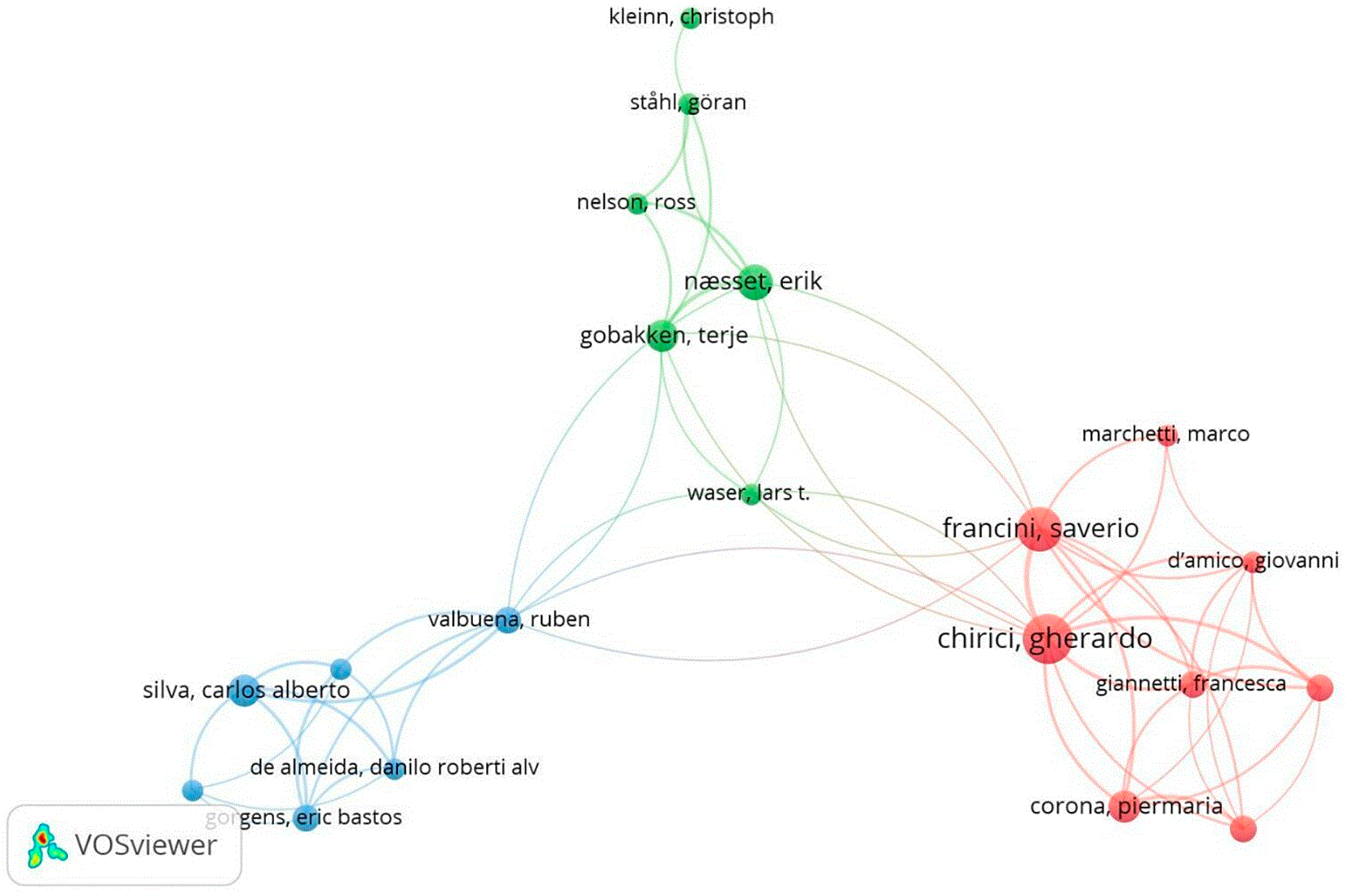
Co-authorship network illustrating collaborative relationships among authors. Node size indicates author productivity, link thickness represents collaboration strength, and colors denote collaborative research clusters.
The first cluster represents the most highly connected group and is dominated by collaborations between researchers from Europe and North America. This position highlights the role of these regions as major centers of knowledge production, generating a substantial share of empirical research on forest monitoring. The second cluster focuses primarily on methodological development, particularly in the areas of forest inventory, ALS, and high-precision remote-sensing applications. The presence of this cluster suggests that methodological innovation has become one of the principal drivers of advancement within the field. Meanwhile, the third cluster reflects the growing involvement of researchers from South America in international collaboration networks, indicating the geographical expansion of the research community and increasing access to global scientific resources.
Differences in the positions actors occupy within the network demonstrate that scientific influence is not always directly associated with network connectivity. Some researchers achieve considerable influence through methodological contributions that become widely adopted and cited across the scientific community. In contrast, others serve as strategic brokers, facilitating knowledge exchange among different research groups. These findings are consistent with scientometric perspectives that regard citations and network centrality as two distinct yet complementary dimensions of scientific influence (Mingers and Leydesdorff, 2015). Citations reflect the intellectual impact of scholarly work, whereas network connectivity represents an actor’s capacity to establish, sustain, and strengthen scientific collaboration flows (Aksnes, Langfeldt and Wouters, 2019).
The collaboration structure observed in this study suggests that a combination of methodological leadership, scientific productivity, and cross-regional integration supports the development of remote sensing for forest monitoring. This pattern reflects a transition towards an increasingly interconnected global knowledge system, in which innovation is generated not only by traditional research centers but also through the participation of a more diverse scientific community. Consequently, the advancement of the field depends not solely on the volume of publications produced but also on the ability of collaboration networks to accelerate knowledge diffusion, facilitate methodological transfer, and foster the emergence of new research agendas at the international level.
Country-level collaboration mapping based on citation networks using VOSviewer reveals that research on remote sensing for forest monitoring has developed into a global network that remains unevenly distributed across countries ( Figure 5 and Table 5). The network consists of several countries that function as major centers of collaboration and knowledge production, while others remain at lower levels of connectivity. This pattern indicates that scientific contributions and influence within the field are concentrated among a relatively small group of countries possessing strong research capacities and extensive international collaboration networks.
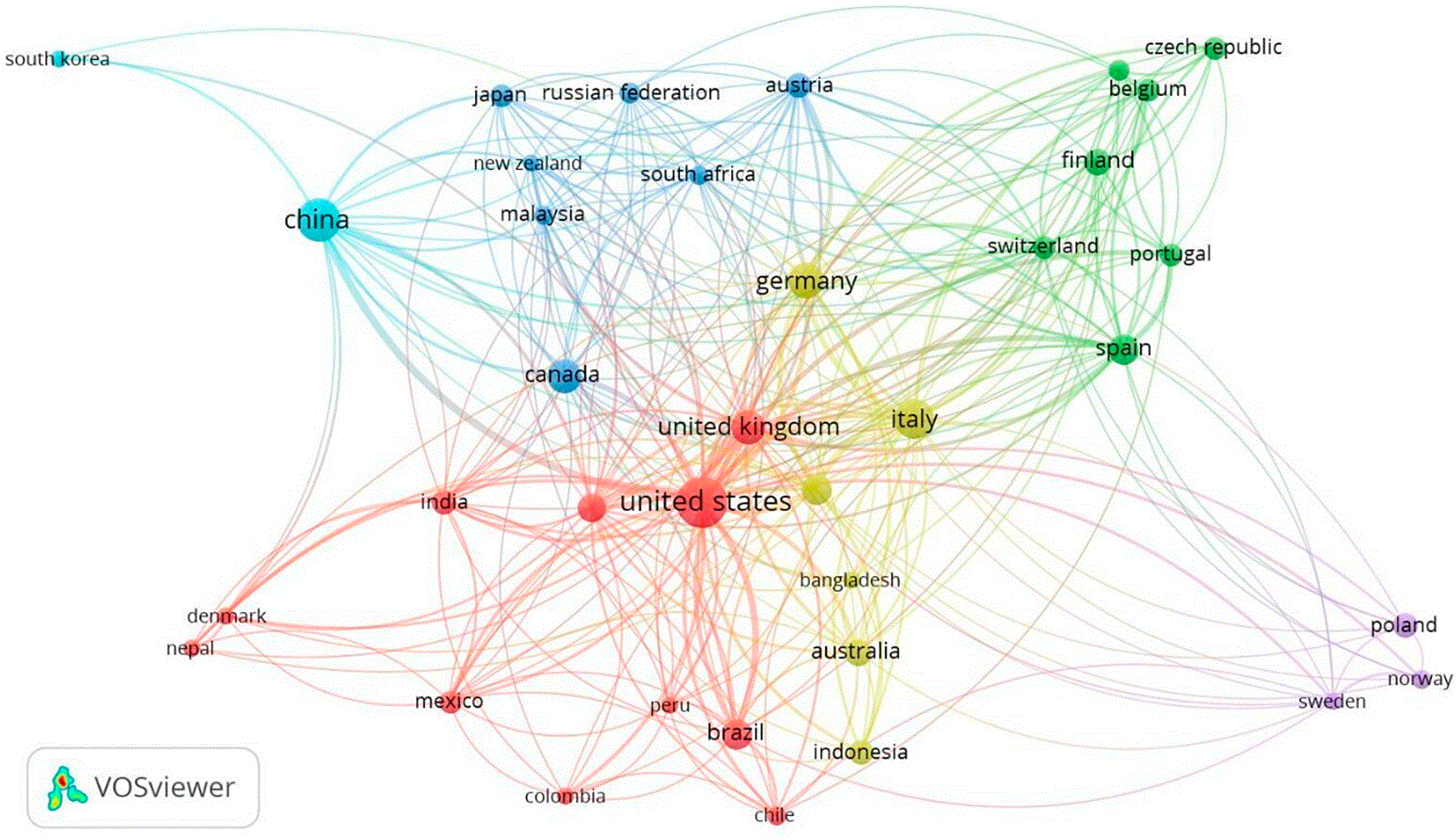
International collaboration network among countries contributing to remote sensing for forest monitoring research. Node size represents publication output, link thickness indicates collaboration intensity, and colors identify country collaboration clusters.
The United States occupies the most central position within the international collaboration network. It has made substantial contributions to the development of major research approaches, including land-cover change analysis, biomass modeling, and large-scale forest monitoring. In Europe, Germany, the Netherlands, the United Kingdom, Italy, France, and Switzerland form a highly interconnected collaborative group that has played a significant role in methodological development and the integration of cross-national research efforts. The United Kingdom serves as a key bridge linking European networks with the broader global scientific community, while Italy strengthens connectivity within the European research landscape.
Within the Asia–Pacific region, China has demonstrated a remarkable increase in scientific contributions and has emerged as one of the leading actors in satellite-based forest-monitoring research. Meanwhile, Brazil is steadily expanding its participation in international research networks. These patterns suggest that engagement in the field is becoming increasingly widespread, although levels of integration and influence continue to vary considerably among countries.
The contrast between China’s dominance in scientific output and the United States’ leadership in citation influence highlights a functional differentiation within the global knowledge system. China acts as a major engine of publication growth through substantial investments in research capacity and the large-scale utilization of Earth observation data. In contrast, the United States maintains a high level of intellectual influence through its contributions to theoretical development, methodological innovation, and the creation of benchmark datasets that are widely adopted by the international scientific community. Similar patterns have been reported in scientometric studies demonstrating that publication volume is not always directly associated with scientific impact (Kaur et al., 2015; Havemann, 2021; Zhu et al., 2025).
Furthermore, previous studies suggest that publication productivity alone does not necessarily translate into greater citation influence. Researchers and institutions that prioritize publication volume over scientific significance may not achieve a proportional increase in scholarly impact. Consequently, a strong focus on increasing publication output alone is unlikely to enhance scientific influence unless it is accompanied by high-quality research, methodological innovation, and contributions that advance the broader knowledge base of the field (McGlothlin and Killen, 2010). The findings therefore underscore the importance of balancing research productivity with intellectual contribution in shaping long-term scientific influence.
Keyword co-occurrence analysis reveals that the conceptual structure of remote sensing for forest monitoring is shaped by strong interconnections among several major research themes ( Figure 6). Within this network, remote sensing occupies a central position and functions as a bridge linking ecosystem observation, computational modeling, and the measurement of forest biophysical characteristics. According to the science-mapping perspective, the centrality of a concept reflects its role in integrating diverse research streams and facilitating knowledge exchange across domains (Budhiraja and Dhall, 2026). These findings indicate that the field has progressed beyond isolated sensor applications and is increasingly characterized by the integration of data sources, analytical methods, and research objectives within a broader interdisciplinary framework.
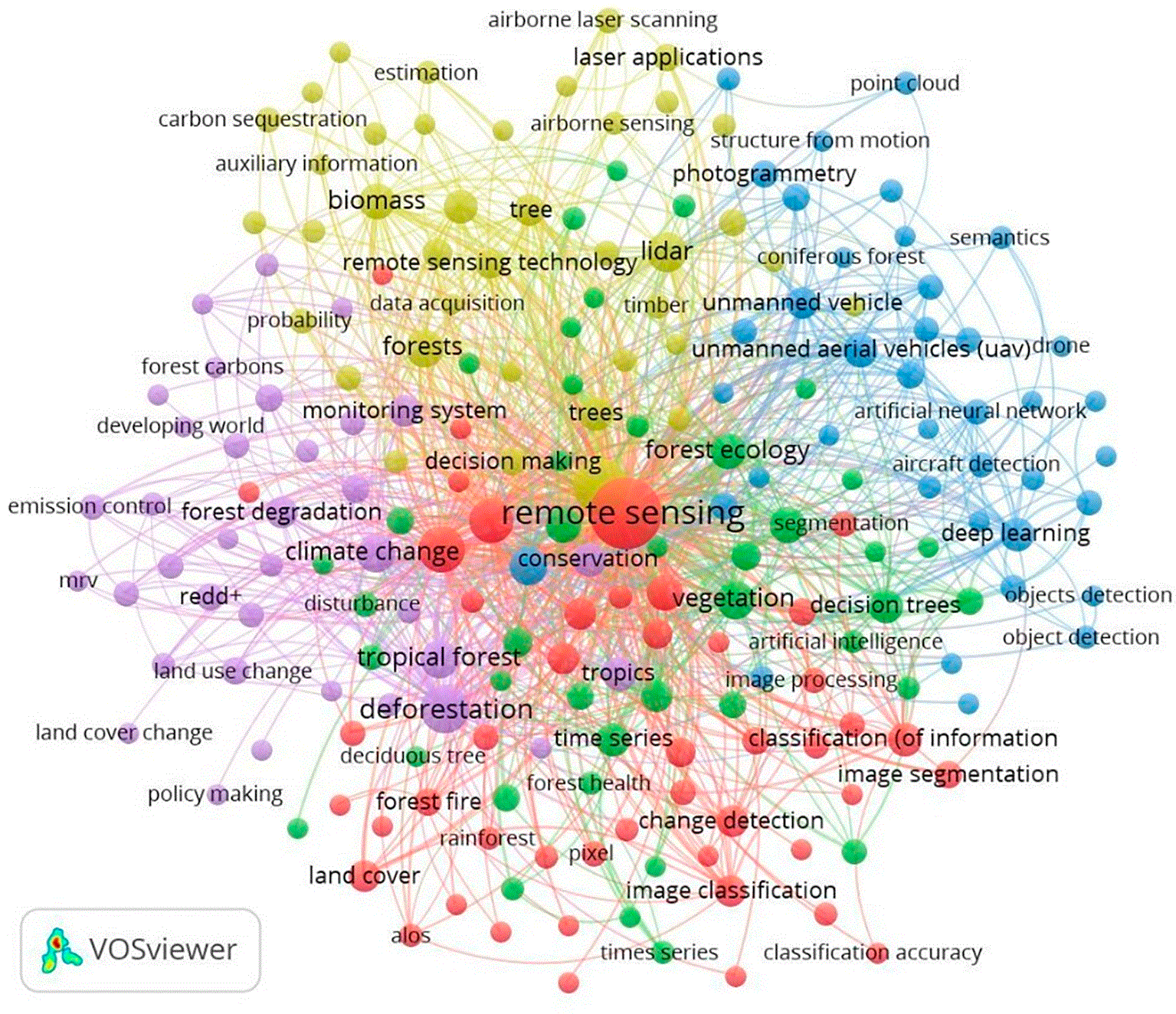
Keyword co-occurrence network generated from author keywords. Node size reflects keyword frequency, links indicate co-occurrence relationships, and colors represent thematic research clusters within the literature.
The network reveals five major clusters that perform complementary functions. The forest-change cluster focuses on deforestation, forest degradation, and land-cover change, which constitute the foundation of long-term forest observation. The quantitative ecology cluster connects remote sensing data to the analysis of ecological processes and ecosystem dynamics. The computational cluster reflects the growing application of machine learning, deep learning, and AI to improve the accuracy and efficiency of information extraction from satellite data. The biophysical cluster centers on the use of LiDAR and ALS for forest structural characterization and biomass estimation. Meanwhile, the carbon and environmental policy cluster links observational outputs with the requirements of emissions reporting, conservation planning, and natural-resource governance.
The relationships among these clusters suggest that the transformation of the field has been driven primarily by the convergence of advances in sensor technologies, developments in computational methods, and the growing demand for environmental information. The strong linkage between the computational and biophysical clusters indicates a shift from descriptive approaches towards more predictive and analytical systems. At the same time, the close association between forest-change research and carbon-policy themes reflects the increasing orientation of the field towards climate-change mitigation, carbon accounting, and sustainable forest management. This pattern is consistent with broader trends in scientific development, characterized by interdisciplinary integration and the growing importance of data-intensive approaches to knowledge generation (Kwon, 2022).
The resulting conceptual structure further demonstrates that contemporary research frontiers extend well beyond improvements in classification accuracy or the development of new sensor technologies. Emerging directions include the integration of foundation models for Earth observation image analysis, the application of explainable AI to enhance the transparency and interpretability of predictive models, the development of digital twin forest ecosystems for simulating forest dynamics, near-real-time forest-monitoring systems based on multi-source Earth observation data, and climate-smart forest governance approaches that connect remote-sensing information with environmental decision-making processes. The emergence of these themes signifies a broader transition from forest-condition observation towards environmental intelligence systems that are predictive, adaptive, and capable of supporting sustainable forest management.
The keyword co-occurrence analysis presented in Figure 7 indicates that the conceptual development of remote sensing for forest monitoring has progressed through a consistent shift in focus from forest-change observation towards data-driven analytics and computational intelligence. This pattern reflects a broader transformation within the Earth observation domain, characterized by a transition from descriptive spatial interpretation to analytical systems capable of extracting, modeling, and predicting ecosystem dynamics using multi-temporal and multi-source data.
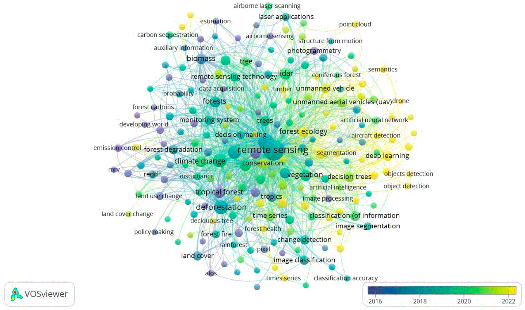
Overlay visualization showing the temporal evolution of research topics based on author keyword co-occurrence. Node colors represent the average publication year, highlighting shifts from earlier to more recent research themes and emerging research frontiers.
The early stage of development was dominated by themes such as deforestation, forest degradation, land-cover change, and change detection, which served as the empirical foundation for satellite-based forest monitoring. During this period, research primarily focused on identifying land-cover changes and vegetation characteristics through optical image interpretation and conventional spatial analysis. The prominence of these themes suggests that the principal objective of the scientific community at the time was to generate baseline information on forest conditions and dynamics across different observational scales.
A significant transformation became evident with the emergence of computational themes such as deep learning, artificial intelligence, image processing, segmentation, and object detection as integral components of the field’s conceptual structure. This shift was associated with the increasing availability of high-resolution Earth observation data, advances in parallel computing, and the emergence of cloud-computing platforms capable of processing large-scale geospatial datasets. During this phase, LiDAR and ALS retained their strategic importance as sources of three-dimensional information supporting biomass estimation, carbon-stock assessment, and the characterization of forest structural attributes.
The most recent period demonstrates increasingly strong linkages between sensor technologies, AI, and environmental analytics. The growing association between computational approaches and high-resolution remote sensing indicates that research is no longer centered on the independent development of sensors or algorithms, but rather on the integration of multiple data sources to generate more accurate, operational, and actionable information. This finding is consistent with the view that scientific evolution occurs through paradigm integration, whereby technological innovation and application-driven needs converge to create increasingly complex research configurations (Li and Yu, 2023).
The resulting conceptual structure suggests that remote sensing for forest monitoring has undergone a transition from an observational paradigm to an analytical–predictive paradigm. This shift has expanded the capabilities of biophysical approaches through the application of artificial intelligence, multi-sensor integration, and large-scale data processing. Such developments are reflected in monitoring systems that combine the IoT and AI to collect and analyze environmental data in real time, enabling anomaly detection and supporting faster and more accurate decision-making processes (Zheng, 2026). Furthermore, the integration of satellite imagery, LiDAR, UAVs, and field-based measurements has enhanced the accuracy of forest-cover mapping, biomass estimation, and carbon-stock assessment (Kumar et al., 2025). These findings suggest that future research frontiers will increasingly focus on intelligent monitoring systems capable of detecting, predicting, and supporting sustainable forest management and climate-change mitigation in near real time.
The transformations identified in remote sensing for forest monitoring represent more than a simple shift in research themes. The transition from land-cover change detection to computational intelligence-based approaches reflects a broader scientific paradigm shift, in which new methods and analytical frameworks progressively replace previously dominant approaches (Manandhar, Odeh and Pontius, 2010; Alshahrani et al., 2025). The growing prominence of machine learning, deep learning, and spatial analytics demonstrates that scientific excellence is no longer determined solely by the capacity to acquire data, but increasingly by the ability to process, integrate, and generate predictions from ever-expanding volumes of information. This transformation has been facilitated by the availability of open Earth observation archives, improvements in sensor resolution, and advances in computing capabilities, enabling analyses at scales previously difficult to achieve.
The evolutionary patterns identified in this study also extend current understanding of scientific development. Although theories of literature growth suggest that the advancement of a research field is generally accompanied by increasing differentiation and specialization (Furner, 2003), the findings indicate that remote sensing for forest monitoring has evolved through a process of specialization followed by interdisciplinary reintegration. A field that initially focused on land-cover change mapping subsequently expanded into forest inventory, biomass assessment, carbon accounting, ecosystem disturbance analysis, artificial intelligence, and environmental modeling, before reconnecting through shared analytical platforms and methodologies. This pattern suggests the emergence of a hybrid evolutionary trajectory, in which the interaction between technological innovation and socio-environmental demands shapes scientific development. Consequently, the advancement of the field is determined not only by growth in publications but also by the convergence of diverse knowledge domains to address increasingly complex environmental challenges.
The distribution of scientific contributions further reveals a differentiation of roles within the global knowledge system. The United States continues to dominate citation influence through its contributions to theory development, methodological innovation, and the widespread adoption of benchmark datasets. China has emerged as the primary driver of publication growth through substantial investments in Earth observation technologies, artificial intelligence, and geospatial data infrastructure. Meanwhile, Europe plays a crucial role in methodological advancement, particularly in the areas of forest inventory, airborne laser scanning, and biomass estimation. This pattern demonstrates that the development of the field is no longer controlled by a single center of knowledge production but rather by a multipolar system shaped by the comparative strengths of different regions. These findings enrich the science-of-science perspective, which emphasizes the importance of the distribution of research capacity and global connectivity in scientific knowledge production (Gui, Du and Liu, 2024).
The network analysis also supports the argument that innovation frequently emerges at the intersection of distinct scientific communities (Teodoro, Faundez-Zanuy and Esposito, 2025). Actors that function as bridges between research groups play a strategic role in accelerating the transfer of methods, concepts, and novel approaches (Chen and Lin, 2017; Herfeld and Doehne, 2019; Gangaliuc, Danko and Husar, 2025). In this context, progress within the field is determined not only by productivity or citation counts but also by the capacity to integrate remote sensing, ecology, computer science, and environmental policy within a coherent and interdisciplinary research framework. This structure helps to explain the acceleration of conceptual development observed alongside increasing levels of cross-disciplinary collaboration.
Despite rapid methodological progress, the distribution of research attention remains uneven. Most publications continue to focus on land-cover change, biomass estimation, and carbon accounting. In contrast, forest degradation, long-term ecosystem dynamics, social–ecological interactions, and forest resilience mechanisms remain comparatively underexplored. This imbalance suggests that the capacity to detect environmental change has advanced more rapidly than the ability to explain the underlying ecological and socio-environmental processes. Consequently, stronger integration among spatial observation, ecological theory, and social dimensions is required to achieve a more comprehensive understanding of forest systems.
The thematic overlay analysis further indicates that research frontiers are no longer confined to improving classification accuracy or developing new sensor technologies. The emergence of foundation models, explainable artificial intelligence, digital twin forest ecosystems, near-real-time monitoring, and climate-smart forest governance reflects a shift in emphasis from observation and detection towards prediction, simulation, model interpretability, and the integration of observational outputs into environmental decision-making processes. Accordingly, the principal challenge for the coming decade will not be the acquisition of data itself, but the development of systems capable of producing reliable, transparent, and operational information to support sustainable forest governance and climate-change mitigation.
This study examined the evolution of remote sensing for forest monitoring from 1980 to 2025 using a bibliometric and science mapping approach. The findings reveal sustained growth in the literature, characterized by a transition from an initial focus on land-cover change towards research integrating Earth observation, computational analytics, and environmental applications. The intellectual structure of the field is shaped by influential authors, institutions, and reference sources that serve both as conceptual foundations and drivers of methodological advancement. Collaboration networks demonstrate increasingly strong connections among North America, Western Europe, and East Asia, the principal centers of knowledge production and diffusion. Conceptual analysis further highlights a transformation from observational approaches towards an analytical–predictive paradigm that incorporates artificial intelligence, multi-source data integration, and large-scale data processing. Furthermore, the emergence of foundation models, explainable artificial intelligence, digital twin forest ecosystems, near-real-time monitoring, and climate-smart forest governance points to the future direction of research within the field.
The theoretical contribution of this study lies in its explanation of how intellectual structures, collaboration networks, and conceptual dynamics have evolved simultaneously over four and a half decades. These findings reinforce science-of-science perspectives that emphasize interactions among scientific communities, methodological innovation, and socio-environmental demands as key drivers shaping the evolution of scientific domains. From a methodological standpoint, the integration of performance analysis and science mapping provides a more comprehensive understanding of the relationships among scientific productivity, intellectual foundations, collaboration patterns, and thematic development.
The practical implications of this study extend to technology development, environmental policy, and natural-resource management. The findings indicate that advances in forest-monitoring systems increasingly depend on the ability to integrate diverse data sources and analytical technologies in order to generate accurate and timely information. These insights are particularly relevant to carbon reporting, REDD+ implementation, climate target assessment, and evidence-based forest management. Moreover, the scientific landscape mapped in this study can assist research institutions, environmental organizations, and policymakers in setting investment priorities, strengthening international collaboration, and shaping research agendas that effectively respond to emerging global environmental challenges.
Several limitations should be acknowledged. Reliance on Scopus as the sole data source may limit representation of the broader literature, while metadata-based analyses cannot fully capture the substantive content of scientific publications. Future research should therefore consider integrating Scopus with additional databases such as the Web of Science, Dimensions, and The Lens to broaden analytical coverage. Bibliometric approaches may also be complemented by systematic literature reviews, content analysis, topic modeling, and natural language processing techniques to provide deeper insights into the evolution of concepts and methodologies. Furthermore, more focused investigations of forest degradation, carbon dynamics, ecosystem resilience, and adaptive monitoring systems are needed to identify remaining research gaps and strengthen future research agendas.