Просмотр новости
Найдите то, что Вас интересует
 Спутники
 РН
РН SpaceX
 Роскосмос
 NASA
NASA
СпутникиРНSpaceXРоскосмосNASABackground Indonesia’s peatlands are highly vulnerable to fire during prolonged dry periods, particularly under El Niño conditions. The 2015 fire crisis highlighted the devastating economic, health, and environmental impacts of uncontrolled peat fires. To address this, the Fire Risk System (FRS) was developed to provide seasonal forecasts and enable anticipatory action. Complementary restoration measures such as canal blocking and community fire preparedness have also been implemented to reduce fire risk. Methods We analysed hotspot data from NASA’s MODIS satellites (2001–2024) and rainfall records from Indonesia’s Meteorological Agency. Regression models quantified the relationship between fire incidence and climatic variables, including rainfall anomalies and rainy season onset. Intervention impacts were assessed by comparing districts with active FRS implementation and restoration measures against those without systematic interventions. Statistical tests were used to evaluate differences in hotspot counts and density, with additional analysis of El Niño years. Results Regression models explained 31–58% of the variance in hotspot occurrence across eight high-risk districts. Increased rainfall significantly suppressed fire activity, while the onset of the rainy season improved predictive accuracy in Riau districts. Following the FRS rollout, hotspot counts declined sharply, with reductions exceeding 90% during the 2023 El Niño compared to 2015. Districts combining FRS with restoration, particularly Barito Selatan, consistently recorded lower hotspot counts and densities than comparable districts such as Kapuas. Community-based fire brigades and fire-free livelihood pilots further enhanced resilience. Conclusions The integration of anticipatory climate services with ecological restoration has proven highly effective in reducing peat fire incidence in Indonesia. FRS enables timely preparedness and resource mobilisation, while canal blocking and rewetting reduce underlying vulnerability. Regional variation underscores the importance of governance and institutional uptake in maximising system effectiveness. Together, these approaches demonstrate a scalable pathway to mitigate fire risk and protect health, ecosystems, and livelihoods in fire-prone peatland regions.
Corresponding author: johan kieft Competing interests: No competing interests were disclosed.
Grant information: This research was funded by the Office of U.S. Foreign Disaster Assistance of the United States Agency for International Development (USAID) through the GAMBUT Project.
The funders had no role in study design, data collection and analysis, decision to publish, or preparation of the manuscript.
Copyright: © 2026 kieft j et al. This is an open access article distributed under the terms of the Creative Commons Attribution License, which permits unrestricted use, distribution, and reproduction in any medium, provided the original work is properly cited. How to cite: kieft j, Boer R and dwi jadmiko s. Quantifying the Impact of the Use of a Seasonal Fire Risk Prediction System in Terms of Reduced Peat Fire Incidence for High Fire Risk Jurisdictions in Indonesia [version 1; peer review: 1 approved with reservations]. F1000Research 2026, 15:1154 (https://doi.org/10.12688/f1000research.176742.1) First published: 14 Jul 2026, 15:1154 (https://doi.org/10.12688/f1000research.176742.1) Latest published: 14 Jul 2026, 15:1154 (https://doi.org/10.12688/f1000research.176742.1)
The 2015 fire crisis in Indonesia constituted an economic and environmental disaster of global proportions. When 2.6 million hectares of land burned, Indonesia incurred estimated losses of USD 16.1 billion (IDR 221 trillion), equivalent to 1.9 per cent of 2015 gross domestic product (GDP). The crisis contributed to the deaths of 19 people and more than 500,000 cases of acute respiratory infections, with immediate health costs totalling USD 151 million (World Bank Group, 2016). Approximately 33 per cent of the total burned area was peatland, resulting in toxic haze that blanketed parts of Indonesia and neighbouring regions, disrupting transportation, trade, tourism, forcing school closures, and negatively affecting health (World Bank Group, 2016; The Guardian, 2015). In response, over USD 300 million was spent on aerial firefighting aircraft, and 22,000 military and police personnel were mobilised to fight fires (World Bank Group, 2016).
Indonesia’s peatlands are particularly vulnerable to fire during prolonged dry periods. As tropical peats are ombrotrophic, their hydrology is driven by rainfall patterns in coastal lowlands subject to a Tropical Rainforest climate. During dry periods, when peat is exposed to air, it becomes highly susceptible to ignition and can sustain smoldering combustion for extended periods (Page et al., 2009; Hayasaka et al., 2019). The relationship between rainfall deficits and fire incidence is well-documented, with El Niño events significantly amplifying fire risk (Marlier et al., 2012; Taufik et al., 2018).
Ecosystem-based disaster risk reduction (Eco-DRR) approaches have emerged as critical strategies for mitigating fire risk. The United Nations Environment Programme (UNEP, 2022) emphasises that restoring degraded peatlands through rewetting and revegetation reduces vulnerability to fires and subsidence. Community-based fire management programs, such as Masyarakat Peduli Api (MPA), play a vital role in implementing these strategies, although challenges such as limited funding and a lack of incentives persist (Nurhidayah et al., 2023; Purnomo et al., 2019). Traditional fire knowledge systems also contribute to fire management in peatlands, particularly in rural areas (Susanto et al., 2025).
The Generating Anticipatory Measures for Better Use of Tropical Peat Lands (GAMBUT) Project was funded by the Office of U.S. Foreign Disaster Assistance of the United States Agency for International Development (USAID) and aimed to address these challenges through the development and implementation of a fire risk system (FRS). The project involved collaboration among UNOPS (executing agency), UNORCID as the implementing agency (UNOPS took over the implementation after the agency finished its mandate in 2016), UN Environment (technical advisor), the Centre for Climate Risk and Opportunity Management in Southeast Asia Pacific (CCROM-SEAP) at the Institute Pertanian Bogor (IPB) and the Earth Institute at Columbia University (developers of the climate-based and web-hosted FRS). The FRS was designed to provide fire risk forecasts up to 6 months in advance, enabling policy makers and decision-makers to implement preventive actions and mobilise resources before predicted fire outbreaks.
Anticipatory climate services, such as FRS, align with global initiatives such as the Early Warnings for All (EW4All) program, which aims to achieve universal coverage of multi-hazard early warning systems by 2027 (Kruczkiewicz et al., 2023; United Nations, 2022). Studies on anticipatory action underscore the importance of linking climate services with governance frameworks to enhance resilience and reduce disaster impacts (Poole et al., 2022). Kieft et al. (2016) further argue that anticipatory management of peat fires can enhance local resilience and reduce natural capital depletion, emphasising the need for integrated approaches that combine predictive systems with ecological restoration.
This study aims to quantify the impact of FRS implementation on peat fire incidence in high-risk Indonesian districts, examining both the direct effects of early warning systems and the complementary effects of peatland restoration interventions. The research addresses the following objectives: (1) to assess the relationship between climatic variables and fire incidence using regression analysis; (2) to evaluate the effectiveness of FRS-based early warning in reducing hotspot counts; and (3) to compare fire outcomes between districts with integrated FRS-restoration approaches versus those without systematic interventions.
The study focused on eight high-risk peat fire districts in Indonesia: four districts in Riau Province (Siak, Bengkalis, Rokan Hilir, Dumai) and four districts in Central Kalimantan Province (Kapuas, Barito Selatan, Pulang Pisau, Palangkaraya). These districts were selected based on historical fire incidence, peatland extent, and participation in the GAMBUT Project.
Hotspot data representing fire incidence were obtained from NASA’s Terra and Aqua satellites (MODIS) for the period 2001–2024. Hotspots were defined as thermal anomalies indicating active fire or recent burning. Rainfall data were collected from meteorological stations operated by Indonesia’s Meteorological, Climatological, and Geophysical Agency (BMKG). The onset of the rainy season was determined using standard criteria: the first occasion after 1 September when cumulative rainfall over three consecutive dekads (10-day periods) exceeded 50 mm, with no subsequent dry period longer than 10 days.
Additional variables incorporated into the analysis were rainfall anomaly (three months before the hotspot peak), consecutive dry days, peat depth, land-use classification, and FRS activation status. Land use data were derived from Indonesia’s Ministry of Environment and Forestry, while peat depth information was obtained from peatland inventory maps.
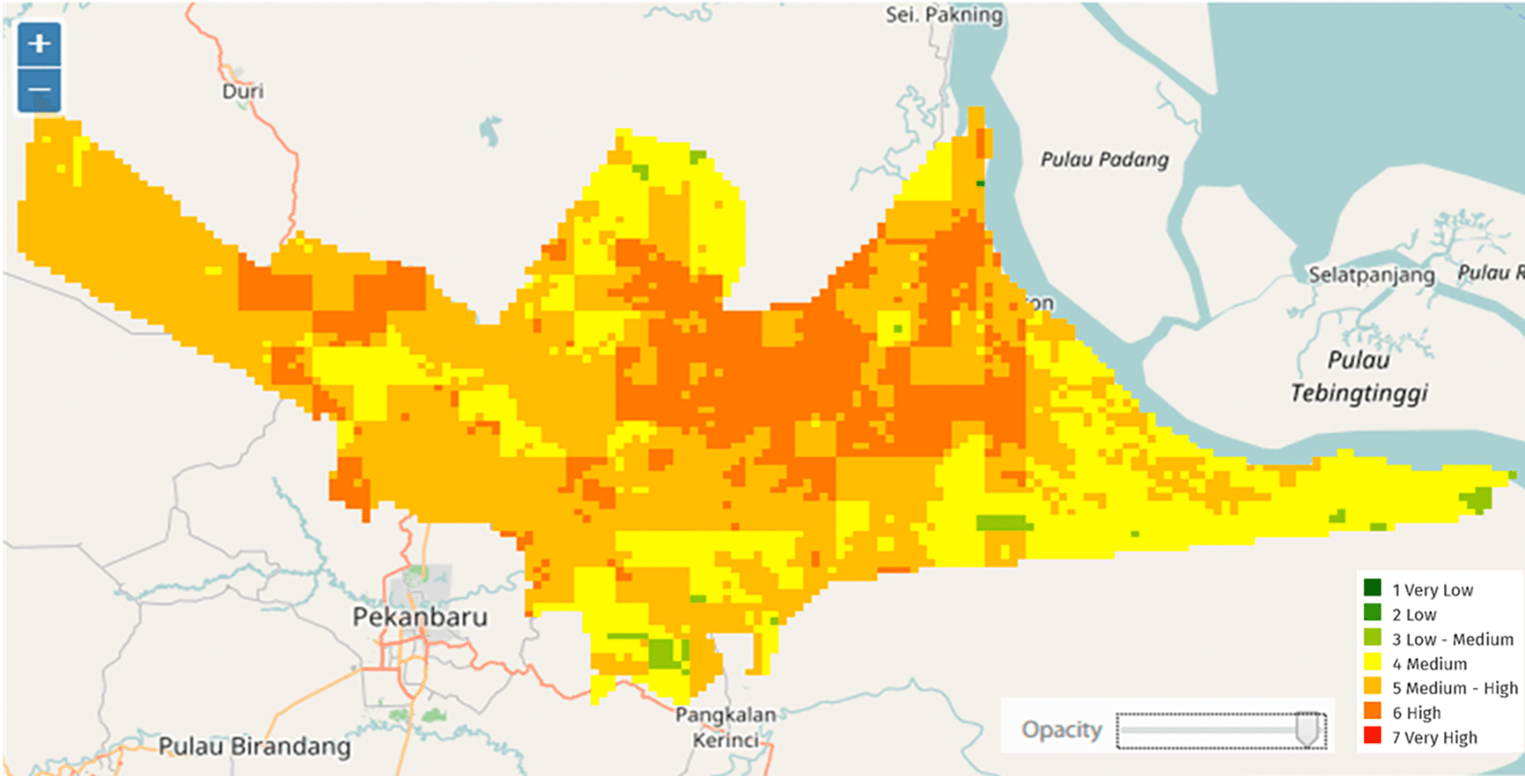
• The FRS provides probabilistic information on fire activity likelihood using three primary products: (1) fire vulnerability maps calculated from biophysical, socio-economic, and infrastructural variables including population density, distance to roads, rivers, and village centers, local GDP, peat depth, land system and cover, and proportion of land under timber, logging, and palm oil concessions; (2) hotspot prediction probability derived from relationships between rainfall patterns and historical hotspot density; and (3) fire risk prediction matrices combining vulnerability and hotspot prediction to produce seven risk categories ranging from very low to very high.
• The temporal scale of FRS products includes: (a) one-year fire vulnerability maps for identifying priority areas for prevention activities; (b) 1–3 month lead time for optimal fire activity forecasting; and (c) extendable 6-month lead time for extended forecasting. The FRS produces outputs at the provincial and district levels, and is scalable to the Forest Management Unit and village levels.
Figure 1 illustrates the timeline for fire prevention implementation in Indonesia, showing the relationship between FRS information delivery and decision-making windows. The system provides seasonal forecasts that enable integration into annual budget planning cycles, distinguishing it from near-real-time “nowcast” systems designed for immediate fire suppression.
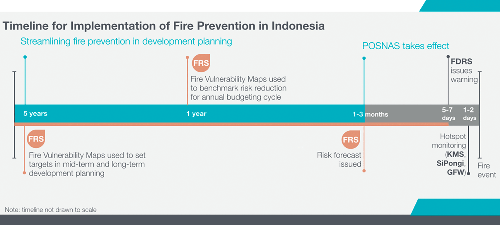
The FRS provides probabilistic information on the likelihood of fire activity. Figure 1 illustrates a timeline of the information the FRs provided over time. In Figure 2, an example of processed data provided by the FRS is shown. Figure 2. An illustration of a fire risk map produced for May 2017 (lead time 3 months) and issued in March 2017 for the Siak District in Riau.
Nature of information. Fire risk predictions are derived from the dynamics of climate and fire on a seasonal timescale and are thus suitable for fire risk and fire prevention efforts, rather than the suppression of near-term fire events. FRS represents a forecast, not a nowcast.
The relationship between fire incidence and climatic variables was quantified using log-transformed regression models. The main regression model was specified as:
log(HSij)=a0+a1·log(CHij)+eij
Where: HSij = number of hotspots, CHij = rainfall in the month k−1 for year k in district- j,eij = error term (assumed random, normally distributed).
To test whether the residuals from the main model were independent and random, or whether they were correlated with the onset of the rainy season, residual analysis was conducted using:
where εi = residual from principal regression, HMi = onset day of rainy season for the district i , ηi = new error term (random, independent).
The null hypothesis H0: β1=0 states that no relationship exists between residuals and rainy season onset. If H1: β1≠0 It is significant that the main model is incomplete, and the rainy season onset should be included as a predictor.
Additional variables tested to improve model robustness included rainfall anomaly (three months before the hotspot peak), peat depth or organic layer thickness, fire readiness status (FRS activation as a policy-intervention dummy variable), extent of open land/plantations, and consecutive dry days. Model coefficients were estimated using ordinary least squares regression, with data from 2001–2013 for model development and from 2014–2024 for validation.
GAMBUT Project interventions implemented across study districts were classified into two categories: (1) FRS-based early warning interventions, including district training, vulnerability mapping, action plan development, awareness campaigns, and stakeholder engagement; and (2) physical restoration interventions, including canal blocking, revegetation, community fire brigade training (Masyarakat Peduli Api - MPA), and fire-free livelihood pilots.
Canal-blocking effectiveness was specifically evaluated by comparing Barito Selatan (which implemented FRS-guided canal blocking in the Dusun Hilir cluster, combined with hydrological assessments and community fire preparedness) with Kapuas (which did not implement systematic FRS-guided restoration). Both districts experienced similar climatic conditions, making them suitable for comparison. Hotspot counts and hotspot density (hotspots/km2) were calculated for both districts over the period 2019–2023.
Statistical significance of regression coefficients was assessed using t-tests with alpha = 0.05. Model fit was evaluated using R2 (coefficient of determination). For the canal-blocking comparison, independent-samples t-tests and nonparametric Mann-Whitney U tests were conducted to assess differences in hotspot counts between Barito Selatan and Kapuas. Effect size was calculated using Cohen’s d. Hotspot trends over time were evaluated using linear regression of log-transformed hotspot counts against year.
All statistical analyses were conducted using statistical software packages. Confidence intervals were calculated using standard deviation values from simulation results generated using the Crystal Ball application for Monte Carlo uncertainty analysis.
The regression analysis confirms that rainfall anomalies and consecutive dry days are strong predictors of fire activity across all study districts. Table 1 presents the regression coefficient for the main model relating hotspot occurrence to rainfall, along with residual analysis results showing that model residuals are related to rainy season onset.
Negative coefficients for cumulative rainfall (a1) indicate that increased precipitation significantly suppresses fire occurrence across all districts. R2 values ranged from 0.31 (Rokan Hilir) to 0.58 (Palangkaraya), indicating that the model explains 31–58% of the variance in hotspot occurrence.
Districts exhibiting significant relationships between model residuals and rainy season onset (Siak, Bengkalis, Rokan Hilir) suggest that the timing of rainy season onset provides additional explanatory power beyond cumulative rainfall. In these Riau districts, anticipatory systems such as FRS are most effective when combined with favourable climatic conditions.
Districts showing non-significant residual relationships (Dumai, Kapuas, Barito Selatan, Pulang Pisau, Palangkaraya) indicate that the main rainfall model adequately captures fire-climate relationships, with no additional explanatory power from rainy season onset timing. In these Central Kalimantan districts, restoration measures rather than predictive systems alone appear to drive fire reduction.
Table 2 presents climate indicators, hotspot counts, and FRS activation status from 2015 to 2024, spanning strong El Niño years, neutral conditions, and La Niña events.
The 2015 baseline year (pre-FRS) exhibited the highest hotspot counts in both regions during a strong El Niño event. Following FRS implementation and early rollout in 2016, substantial reductions in hotspot counts were observed. The 2019 moderate El Niño year saw increased fire activity compared with 2017–2018, but hotspot counts remained substantially below 2015 levels despite comparable rainfall deficits.
The 2023 El Niño year is particularly notable. Despite negative rainfall anomaly (−85 mm) and El Niño conditions (+1.3 °C SST anomaly), hotspot counts in Riau (102) and Central Kalimantan (198) were dramatically lower than 2019 (3,291 and 3,987, respectively) and more than 90% below 2015 levels. This demonstrates the effectiveness of FRS-based anticipatory action combined with cumulative restoration efforts.
Table 3 summarises GAMBUT interventions implemented in each study district, observed hotspot trends from 2015–2019, and inferred impact.
All districts showed declining hotspot trends during the 2015–2019 period, except for Rokan Hilir, which exhibited fluctuating patterns. Districts combining FRS-based early warning with physical restoration interventions (particularly Barito Selatan) showed the most consistent declines.
Table 4 presents a direct comparison of hotspot counts and hotspot density between Barito Selatan (FRS-guided canal blocking implementation) and Kapuas (no systematic FRS-guided restoration) for the period 2019–2023.
Kapuas consistently recorded 4–6 times as many hotspots as Barito Selatan across all years. Hotspot density per km2 was also consistently higher in Kapuas. Both regions experienced a sharp resurgence in 2023 during El Niño conditions, but the magnitude of increase was substantially lower in Barito Selatan.
Statistical tests (independent samples t-test: t = −1.52, p = 0.21; Mann-Whitney U test: U = 4.0, p = 0.31) indicated no significant difference at conventional thresholds (α = 0.05) due to small sample size (n = 5 per district) and inter-annual variability. However, the medium effect size (Cohen’s d = −0.678) indicates a meaningful practical difference, supporting the interpretation that FRS-guided canal blocking contributed to a reduction in fire incidence in Barito Selatan.
In Barito Selatan, FRS vulnerability maps were used to identify high-risk peat clusters in the Dusun Hilir area to inform targeted canal-blocking interventions. The restoration process integrated cluster-based drainage planning aligned with spatial and concession plans; hydrological assessments to maintain peat moisture and reduce fire risk; community fire brigade training under the Working Group on Tropical Peatland (WOT) program for early suppression; and fire-free livelihood pilots (e.g., Nyamplung agroforestry) to reduce burning incentives.
The insignificant β1 coefficient for Barito Selatan in the residual analysis ( Table 1) suggests that rainy season onset no longer drives residual variation in the regression model, implying improved hydrological resilience resulting from rewetting interventions. In contrast, Kapuas shows persistent sensitivity to rainfall timing, highlighting the absence of effective hydrological interventions.
R2 values from regression models ranged from 0.31 to 0.58 across the eight districts ( Table 1). Palangkaraya (R2 = 0.58) and Pulang Pisau (R2 = 0.56) exhibited the highest explanatory power, suggesting that climatic and intervention variables strongly influence fire dynamics in these districts. Kapuas (R2 = 0.54) and Barito Selatan (R2 = 0.55) also demonstrated robust model performance, though their regression significance for rainy season onset was lower, implying that restoration measures complement predictive systems.
Siak and Bengkalis (both R2 = 0.42) showed moderate explanatory power but significant coefficients for rainy season onset, indicating that institutional uptake of FRS enhances predictive accuracy even when climatic variability is high. Rokan Hilir (R2 = 0.31) showed the weakest explanatory power, possibly due to external pressures such as land-use change or limited institutional engagement.
Districts with higher R2 values benefit from integrated approaches combining anticipatory climate services and restoration interventions. Lower R2 values in some regions highlight the need for additional socio-economic and governance variables to improve model robustness.
The integration of the Fire Risk System (FRS) into district-level planning has produced measurable benefits in reducing fire incidence and associated health risks in Indonesian peatlands. By forecasting fire-prone conditions using climate and land-use data, FRS enables early interventions to prevent large-scale peat fires, the primary source of toxic haze affecting Indonesia and neighbouring countries.
The dramatic reduction in hotspot counts following FRS implementation—from 3,221 (Riau) and 4,112 (Central Kalimantan) in 2015 to 102 and 198, respectively, in 2023, despite comparable El Niño conditions—demonstrates the effectiveness of anticipatory climate services for fire prevention. This represents more than 90% reduction in fire incidence during comparable climatic stress conditions. The 2023 results are particularly significant because they occurred during an El Niño year with substantial rainfall deficit (−85 mm anomaly), conditions that historically triggered extensive fires.
Districts with active FRS implementation, such as Siak and Bengkalis, experienced significant reductions in hotspot counts and improved predictive accuracy. The significant coefficients for rainy season onset in these Riau districts ( Table 1) indicate that FRS-based early warning provides actionable lead time for preparedness measures before the onset of the dry season. Early warning enabled districts to implement prevention activities, including community fire patrols, management of controlled burning permits, water-level monitoring in canals, and pre-positioning of firefighting equipment.
The temporal scale of FRS information aligns well with budgetary and planning cycles in Indonesian districts. One-year vulnerability maps enable annual budget allocation through mechanisms such as the national budget (APBN), specific purpose funds (DAK), and village funds. Three-month lead time hotspot predictions support revised budget allocations (APBN-P) and contingency funds for pre-disaster response. This integration of climate information into governance structures represents a key factor in FRS effectiveness.
The comparison between Barito Selatan and Kapuas provides clear evidence of the added value of integrating FRS-based targeting with physical restoration interventions. While both districts experienced declines in hotspot counts during the study period, Barito Selatan consistently had 75–86% lower hotspot counts and 47–65% lower hotspot density than Kapuas.
Canal blocking guided by FRS vulnerability maps achieved multiple benefits: (1) raising and stabilising water tables in degraded peatlands, reducing peat flammability; (2) targeting interventions to high-risk areas identified through spatial analysis of fire vulnerability; (3) creating demonstration effects for community-based restoration; and (4) integrating hydrological restoration with fire-free livelihood alternatives.
The non-significant relationship between residuals and rainy season onset in Barito Selatan (β1 = −1.5609, p = 0.00522, ns), compared with significant relationships in untreated Riau districts, suggests that hydrological restoration reduced dependence on seasonal rainfall timing for fire prevention. This represents improved ecological resilience: rewetted peatlands retain moisture even when the rainy season onset is delayed.
Community engagement through Masyarakat Peduli Api (MPA) training complemented hydrological interventions. Trained community fire brigades provided early detection and rapid initial response to fire starts, preventing small ignitions from developing into large-scale fires. Fire-free livelihood pilots such as Nyamplung (Calophyllum inophyllum) agroforestry created economic incentives for fire prevention by demonstrating profitable alternatives to slash-and-burn land clearing.
The study revealed important regional differences in FRS effectiveness mechanisms. In Riau districts, institutional uptake and governance factors appear more influential: districts with stronger district government commitment to FRS integration (Siak, Bengkalis) showed better outcomes than districts with weaker institutional engagement (Rokan Hilir). Significant residual relationships with rainy season onset in Riau suggest that early warning information provides the greatest value when there is institutional capacity to act on predictions.
In Central Kalimantan districts, physical restoration appears more influential: districts implementing canal blocking and rewetting (Barito Selatan) showed improved outcomes relative to similar climatic conditions. Higher R2 values in Central Kalimantan districts (0.54–0.58) than in Riau districts (0.31–0.43) suggest that, once hydrological restoration is implemented, fire-climate relationships become more predictable and management more effective.
These regional differences reflect different stages in the fire management intervention continuum. Early warning systems provide the greatest marginal benefit when response capacity exists, but information is lacking. Physical restoration provides the greatest benefit when degraded peatlands create structural fire vulnerability regardless of preparedness. Optimal fire prevention requires both components: early warning to trigger timely action and the restoration of peatlands to reduce underlying vulnerability.
The reduction in fire incidence directly translates to reduced health risks from particulate matter exposure. The 2015 fires generated severe haze affecting over 40 million people across Indonesia, Malaysia, and Singapore. PM2.5 concentrations during peak fire periods exceeded WHO guidelines by factors of 10–50, contributing to hundreds of thousands of respiratory illness cases and excess mortality (Hein et al., 2022).
The predictive ability of FRS enables estimation of PM2.5 concentrations through integration with smoke dispersion models. Machine learning models incorporating temperature, humidity, wind speed, and fire radiative power can forecast PM2.5 levels 24–72 hours in advance, enabling health agencies to issue timely advisories for vulnerable populations, including children, elderly persons, and individuals with respiratory conditions (Khanmohammadi et al., 2024; Muthukumar et al., 2022).
The dramatic reduction in 2023 hotspot counts despite El Niño conditions prevented a repeat of the 2015 and 2019 health crises. While comprehensive health impact data for 2023 are not yet available, the more than 90% reduction in fire incidence suggests proportional reductions in haze-related respiratory illness and associated healthcare costs. This represents a substantial return on investment for FRS implementation and peatland restoration programs.
Despite demonstrated effectiveness, scaling FRS implementation faces several challenges. Institutional capacity for utilising seasonal climate forecasts remains limited in many districts. Budget allocation processes do not always accommodate flexible, forecast-based resource mobilisation. Coordination between national, provincial, and district agencies remains incomplete. Land tenure conflicts complicate restoration planning. Limited resources constrain the scale of canal blocking and rewetting interventions.
Successful integration of FRS into district planning requires several enabling conditions: (1) district government leadership committed to prevention rather than suppression; (2) technical capacity to interpret FRS products and translate them into operational plans; (3) flexible budget mechanisms allowing pre-disaster resource allocation; (4) multi-stakeholder platforms coordinating government, community, and private sector actions; and (5) sustained investment in both information systems and physical restoration.
The study demonstrates that these enabling conditions can be developed through targeted capacity-building programs. GAMBUT Project interventions, including district training, development of action plans, stakeholder engagement platforms, and vulnerability mapping, support institutional development. However, sustaining these capacities beyond project timelines requires mainstreaming FRS into routine district planning and budgeting processes.
This study has several limitations that should be acknowledged. Reliance on satellite-derived hotspot data may underrepresent ground-level fire activity, particularly small fires and smouldering combustion in peat. Hotspot counts do not capture fire intensity, duration, or area burned, which vary considerably. The absence of detailed socio-economic variables limits the analysis of human factors influencing fire occurrence. Small sample sizes for some comparisons (particularly the five-year Barito Selatan-Kapuas comparison) limited statistical power to detect differences.
Future research should incorporate community-based monitoring to complement satellite observations. Ground-truth validation of hotspot data would improve accuracy. Analysis of fire size distributions and burn severity would provide a deeper understanding of fire behaviour. Integration of socio-economic variables, including livelihood patterns, land tenure, and economic incentives, would enable more comprehensive fire risk models. Cost-effectiveness analysis comparing different intervention combinations would inform resource allocation decisions.
Long-term monitoring extending beyond project timelines is essential for evaluating the sustainability of fire reduction. The 2023 hotspot resurgence in both Barito Selatan and Kapuas, while substantially lower than in 2019, highlights the need for ongoing prevention efforts. Climate change scenarios project increased El Niño frequency and intensity, necessitating enhanced resilience measures. Exploring the integration of FRS with other hazard early warning systems (flood, drought, landslide) would support comprehensive disaster risk reduction.
This study demonstrates that anticipatory systems such as Indonesia’s Fire Risk System (FRS), when combined with peatland restoration measures, significantly reduce fire incidence in high-risk districts. Regression analyses linking hotspot occurrence to rainfall and rainy season onset explain 31–58% of the variance in fire, with models performing best in districts implementing both early warning and restoration interventions.
FRS-based early warning reduced hotspot counts by more than 90% in the 2023 El Niño year compared to the 2015 baseline, demonstrating effectiveness under comparable climatic stress conditions. Regional variation exists: Riau districts benefit primarily from institutional uptake of early warning information, while Central Kalimantan districts benefit primarily from physical restoration interventions, including canal blocking.
Direct comparison between Barito Selatan (FRS-guided canal blocking) and Kapuas (no systematic restoration) revealed 75–86% lower hotspot counts and 47–65% lower hotspot density in the restoration district. The statistical effect size (Cohen’s d = −0.678) indicates meaningful practical differences despite limited statistical power due to the small sample size. Non-significant relationships between residuals and rainy season onset in restored districts suggest improved hydrological resilience, reducing dependence on seasonal rainfall patterns.
These results highlight the critical synergy between anticipatory climate services and long-term land-based interventions, reaffirming the importance of governance, accountability, and ecological restoration in mitigating Indonesia’s recurring peat fire crises. The findings support several policy implications:
1. Mainstream FRS into district-level annual planning and budgeting cycles, integrating fire vulnerability indicators into resource allocation formulas for national budgets, specific-purpose funds, village funds, and contingency funds.
2. Scale up FRS-guided canal blocking and rewetting interventions in high-risk peatlands, using vulnerability maps to target restoration resources to areas with the greatest fire prevention benefit.
3. Strengthen institutional capacity for seasonal forecast interpretation and translation into operational preparedness actions, including district training programs, development of standard operating procedures, and establishment of multi-stakeholder coordination platforms.
4. Integrate community-based fire management through Masyarakat Peduli Api programs with early warning systems and fire-free livelihood alternatives, ensuring community participation in both planning and implementation.
5. Develop regional coordination mechanisms for fire prevention, recognising that haze and health impacts cross administrative boundaries and require collaborative approaches.
6. Invest in long-term monitoring and evaluation systems to track fire trends, assess intervention effectiveness, and adapt strategies based on evidence of what works in different contexts.
The global relevance of these findings extends beyond Indonesia. Tropical peatlands in Southeast Asia, Central Africa, and South America face similar fire challenges. The demonstrated effectiveness of integrating seasonal climate forecasts with ecosystem-based disaster risk reduction provides a replicable model for other fire-prone peatland regions. The approach aligns with global frameworks, including the United Nations Early Warnings for All initiative and ecosystem-based adaptation strategies under the UNFCCC.
Canal blocking is an effective peatland restoration strategy for reducing fire risk when guided by spatial targeting based on vulnerability maps. The intervention not only lowers hotspot counts but also stabilises peat moisture, reducing dependence on seasonal rainfall. Scaling up similar measures in other high-risk districts could significantly enhance the effectiveness of fire prevention while generating co-benefits, including greenhouse gas emissions reductions, biodiversity conservation, and improved water regulation.
Future research should focus on cost-effectiveness analyses of different intervention combinations, the long-term sustainability of fire reduction beyond project timelines, the integration of traditional knowledge with scientific early warning systems, and the exploration of FRS applications to other climate-sensitive hazards. Continued innovation in anticipatory action that links climate services with governance and restoration will be essential for building resilience to Indonesia’s recurring fire challenges.
This study did not involve human participants, interviews, or focus groups. Ethical approval was therefore not required. The research relied exclusively on publicly available satellite and meteorological datasets.
If community engagement activities (e.g., fire brigade training or livelihood pilots) were described, they were conducted as part of government-approved programs. They did not involve human subjects research requiring oversight by an institutional review board.
All datasets required to replicate the findings of this study are openly available in the Figshare repository. The data can be accessed at the following persistent link: https://doi.org/10.6084/m9.figshare.31908985. (kieft et al., 2024).
The repository includes:
• Values behind means, standard deviations, and other reported measures.
• Data used to construct graphs and figures.
• Points extracted from images for analysis.
• Variables and metadata descriptions (e.g., rainfall anomalies, hotspot counts, land-use classifications).
All datasets are shared under a CC BY licence and are freely accessible without an embargo or login requirements.
This research was conducted as part of the Generating Anticipatory Measures for Better Use of Tropical Peat Lands (GAMBUT) Project funded by the Office of U.S. Foreign Disaster Assistance of the United States Agency for International Development (USAID). The authors acknowledge the collaboration and support of UNOPS, UN Environment, the Centre for Climate Risk and Opportunity Management in Southeast Asia Pacific (CCROM-SEAP) at IPB University, and the Earth Institute at Columbia University. We thank the district governments of Siak, Bengkalis, Rokan Hilir, Dumai, Kapuas, Barito Selatan, Pulang Pisau, and Palangkaraya for their participation in GAMBUT Project activities and for providing access to local data and personnel. We acknowledge Indonesia’s Meteorological, Climatological, and Geophysical Agency (BMKG) for providing rainfall and climate data, and NASA for making MODIS hotspot data publicly available. We thank community fire brigades (Masyarakat Peduli Api) and local partners who implemented field interventions. The findings and conclusions in this article are those of the authors and do not necessarily represent the views of USAID, UN agencies, or participating institutions.
This research was funded by the Office of U.S. Foreign Disaster Assistance of the United States Agency for International Development (USAID) through the GAMBUT Project.
The funders had no role in study design, data collection and analysis, decision to publish, or preparation of the manuscript.
© 2026 kieft j et al. This is an open access article distributed under the terms of the Creative Commons Attribution License, which permits unrestricted use, distribution, and reproduction in any medium, provided the original work is properly cited.
Current Reviewer Status: ?
Key to Reviewer Statuses VIEW HIDE
ApprovedThe paper is scientifically sound in its current form and only minor, if any, improvements are suggested
Approved with reservations A number of small changes, sometimes more significant revisions are required to address specific details and improve the papers academic merit.
Not approvedFundamental flaws in the paper seriously undermine the findings and conclusions
Version 1
VERSION 1
PUBLISHED 14 Jul 2026
Reviewer Report 27 Jul 2026
Sigit Sutikno, Center for Peatland and Disaster Studies, Universitas Riau, Pekanbaru, Riau, Indonesia
Approved with Reservations
VIEWS 0
Is the work clearly and accurately presented and does it cite the current literature?
Partly
Is the study design appropriate and is the work technically sound?
Partly
Are sufficient details of methods and analysis provided to allow replication by others?
No
If applicable, is the statistical analysis and its interpretation appropriate?
No
Are all the source data underlying the results available to ensure full reproducibility?
No
Are the conclusions drawn adequately supported by the results?
No
Competing Interests: No competing interests were disclosed.
Reviewer Expertise: Peatland Hydrology, GIS and Remote Sensing, Coastal hydrodinamic
Close