Просмотр новости
Найдите то, что Вас интересует
 Спутники
 РН
РН SpaceX
 Роскосмос
 NASA
NASA
СпутникиРНSpaceXРоскосмосNASAAs atmospheric rivers crashed into the High Sierra during the 2022-23 winter, I had two primary reactions. I was: In 2023 backpacking trips in the High Sierra will be more difficult and risky than identical itineraries in past seasons. However, it’s possible to accurately predict, entirely avoid, and/or safely manage the challenges. Personally, I think…
The post High Sierra record snowpack: Implications for trip planning, gear selection, and skills appeared first on Skurka Adventures.
As atmospheric rivers crashed into the High Sierra during the 2022-23 winter, I had two primary reactions. I was:
In 2023 backpacking trips in the High Sierra will be more difficult and risky than identical itineraries in past seasons. However, it’s possible to accurately predict, entirely avoid, and/or safely manage the challenges. Personally, I think this approach is more productive than succumbing to fear mongering (this 2018 post remains relevant today) or letting fears of the unknown grow out of proportion.
In this post I will explain how to have safe and fun trips in the High Sierra by explaining the:
This post shares content with the extensive early-season tutorial that I wrote in 2017. This one is more succinct and updated, and reflects six additional years of gained backcountry wisdom.
What are the likely conditions? In normal yearsAfter winters that track close to the the historical averages, in the high country of Sequoia-Kings, Inyo, Emigrant, and Yosemite, we’d expect:
The arrival of normal conditions will be significantly delayed this season. Instead, most backpackers will experience some “early-season conditions” that normally prevail in May and June that blur the lines between backpacking and mountaineering. Specifically, I’m expecting:
1. More extensive snow coverage, because it will take longer for it to melt off.Many more weeks of summer temperatures will be required to melt this extreme snowpack. High and north-facing slopes will probably remain snowbound into next winter. As a result, expect:
Another condition indirectly related to the long-lasting snow coverage will be an abnormally high number of blowdowns. Storms that bring heavy moisture also usually arrive with heavy winds, causing trees to fall.
 Nearly complete snow coverage still on the north of Selden Pass on the John Muir Trail/Pacific Crest Trail in late-June 2006
2. Overabundant groundwater
Nearly complete snow coverage still on the north of Selden Pass on the John Muir Trail/Pacific Crest Trail in late-June 2006
2. Overabundant groundwater
Some of it will percolate into the soil, which is parched after multiple years of drought. But because the High Sierra is composed of impervious granite and because the high country has little top soil, most of it will flow into streams and creeks that eventually form large rivers like the Kern, Kings, San Joaquin, Merced, and Tuolumne. As a result, expect:
The bugs will hatch after the groundwater becomes warm enough. The volume of cold snowmelt will delay this from happening on a mass scale.
Once the mosquitoes emerge, they probably will stick around until the first frosts in late-September or early-October because many areas will never dry out this season.
Mosquitoes are most active in the evening, seeming to enjoy their supper while you’re having yours. They don’t like temperatures below about 50 degrees (like at night) and they struggle in strong winds.
4. Highly variable conditionsSnow levels, snow consistency, snowmelt rates/river levels, and bug pressure will change throughout each day and from week to week, and vary too with elevation and slope aspect. These dynamics need to be considered when planning whole trips ahead of time and when planning each day.
Trip planning at homeIn advance of your trip, what changes should be made and how can conditions be monitored?
Itineraries and permitsTo monitor snowpack across the western US, throughout the winter I primarily use:
When I’m planning early-season trips though, another data source becomes much more valuable: Sentinel Satellite imagery. It gives me access to:
CalTopo (long-term review) includes Sentinel imagery in its Pro subscription ($50 per year) and has imagery stretching back to January 2017. Select “Sentinel Weekly” base in the Base Layers dropdown menu. New imagery is uploaded weekly.
Imagery from 2017 and 2019 will best inform you of likely snow coverage in 2023. Conditions this season will likely be a few weeks behind these other two seasons, since the 2022-23 was notably wetter. The exact delay will became more evident in late-June or July when more bare ground emerges.
 Sentinel Satellite imagery from July 16, 2017, of the Emigrant Wilderness, which I can use to speculate about snow coverage during our trips that start on July 20, 2023.
Water levels
Sentinel Satellite imagery from July 16, 2017, of the Emigrant Wilderness, which I can use to speculate about snow coverage during our trips that start on July 20, 2023.
Water levels
Real-time data for the most renown crossings in the High Sierra — like the South Fork of the Kings between Pinchot and Mather Passes, Bear Creek north of Selden Pass, and Rancheria Creek in Yosemite’s Kerrick Canyon — is unavailable.
Gauges further downstream are suggestive of what’s happening upstream. Refer to my High Sierra Creek Hazards resource for a list, under the section “Data: Current Levels.”
Speaking of, the Hazards list and map is a definitive resource. Use it before you go when planning your route, and as you go to set your expectations and daily schedule.
 Bug pressure
For the information about current bug pressure, read recent online trip reports and call wilderness offices. But, honestly, these resources are not consistently accurate — rangers may not get out as much as you’d think, online information may not be timely, and the reported conditions may not be relevant to your own itinerary. It’s more productive to simply:
Compared to a normal summertime kit, what changes should be made?
ClothingFor sun protection, have:
For bugs, I recommend at least having a:
Treated pants are optional. Bites below the waist are much less common, probably because mosquitoes struggle to get through the fabric.
You may opt to bring shorts, because they’re more airy and less restrictive than pants. However, they offer no defense against bugs or sun, leaving their usefulness to bug-free wooded sections.
My experience is that DIY permethrin treatments are less effective, in terms of overall effectiveness and in longevity. If you have beloved non-treated hiking clothes, send them to Insect Shield ($9 per item or $120 for 10-15 items).
 Amy in Alaska, sporting a permethrin-treated knit hoody and headnet.
Footwear
Amy in Alaska, sporting a permethrin-treated knit hoody and headnet.
Footwear
Hiking shoes should have a/an:
Carry two pairs of socks:
I prefer wool socks, which are observably warmer (but not “warm”) than synthetic fibers like nylon.
For additional thoughts on early-season footwear, read this post.
Shelter and sleep systemEven though you may be camping on snow and be surrounded by snow, the weather in the High Sierra in July and August is typically benign. My goal each season is to cowboy camp every night; for nights when I can’t, I have an open-sided A-frame tarp.
Trekking polesThis is an essential item for early-season conditions. In addition to their normal usefulness, they’re good for:
Ultralight trekking poles like the Gossamer Gear LT5 should left at home. Instead, go with robust poles like the Black Diamond Alpine Carbon Cork (long-term review) or the Cascade Mountain Tech Quick Lock (long-term review).
Remove the mud baskets and the snow baskets. With baskets, their functionality is partially lost. For example, they’re less effective for probing snow and they add drag while crossing creeks.
Floatation Steve ascends the Northeast Gully on the Pfiffner Traverse in late-June. An ice axe and crampons were critical for this steep 600-foot pitch.
Essential skills
Steve ascends the Northeast Gully on the Pfiffner Traverse in late-June. An ice axe and crampons were critical for this steep 600-foot pitch.
Essential skills
You’ve planned a practical route and you’ve selected appropriate gear. To have a successful trip, skills are the final thing you need.
Decision-makingOnce out there, don’t feel compelled to stick to your plan. Instead, be ready to:
When making decisions, keep in mind the abilities of your weakest group member. The plan must be appropriate for every person in the group, not most of them.
Snow travelSpecific skills to learn include:
 Walking on concrete-hard snow below Muir Pass in mid-May, early in the morning. A few hours later in this same spot,, I’d be postholing to my waist.
Navigation
Walking on concrete-hard snow below Muir Pass in mid-May, early in the morning. A few hours later in this same spot,, I’d be postholing to my waist.
Navigation
For more early-season navigation tips, read this post. For my definitive tutorial on navigation, go here.
 In early-season conditions, the trail is just a tool. If it’s there, great. If not, oh well, you can manage without it.
Avalanche awareness
In early-season conditions, the trail is just a tool. If it’s there, great. If not, oh well, you can manage without it.
Avalanche awareness
Summertime avalanches are very rare, and this is not the risk that keeps me up at night. However, it’s still helpful to know the warning signs for wet slab avalanches:
The slope-angle shading overlay in CalTopo can help you identify slopes.
Foot careExpect wet feet everyday, perhaps all day. And often very cold, too. It’s essential to take care of them. Follow this regimen.
To keep my feet warm and dry in camp without needing to carry dedicated camp shoes, I bring 2 mil bread bags. We buy these bags for our clients, available in 100-count only. Here’s the routine:
 To keep our feet warm in camp, we wore bread bags between our dry sleeping socks and our wet shoes.
River crossings
To keep our feet warm in camp, we wore bread bags between our dry sleeping socks and our wet shoes.
River crossings
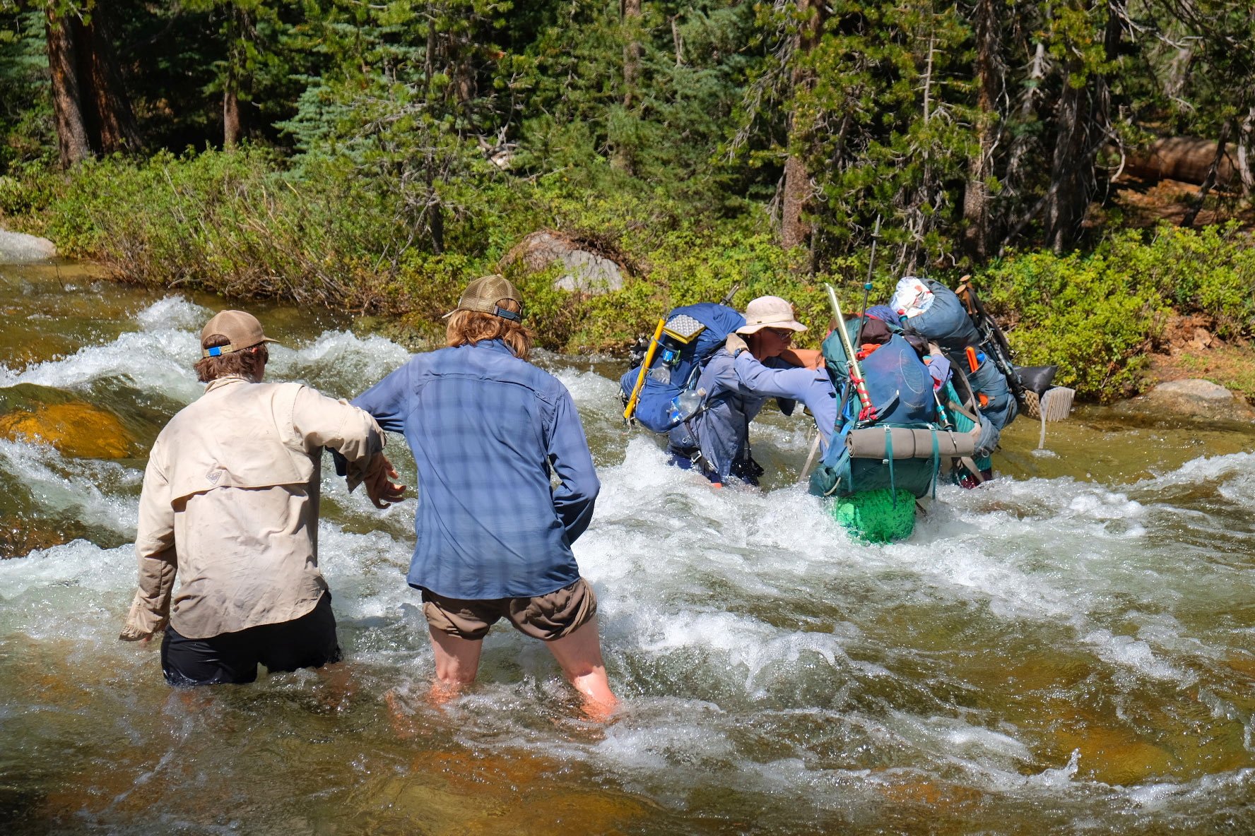
Take crossings seriously. They can be enormously risky, and in 2017 were responsible for two hiker deaths.
Learn to predict the size and swiftness of crossings:
Do not assume that the official trail crossing is safe. Instead, learn to identify safer options, and be willing to invest time in scouting trips up and down the creek where it:
When crossing solo, use trekking poles to maintain a tripod at all times, with three points of contact, e.g. two legs and one pole, one leg and two poles.
Groups can cross creeks that soloists cannot, or not as safely. Specific techniques include the:
For more river crossing discussion, read this post.
 In late-June after a very wet winter, I crossed I crossed Evolution Creek at the meadow about a half-mile above the trail crossing. Here, at 5 PM, it was MUCH safer. The trail crossing would have been a swim.
Bug management
In late-June after a very wet winter, I crossed I crossed Evolution Creek at the meadow about a half-mile above the trail crossing. Here, at 5 PM, it was MUCH safer. The trail crossing would have been a swim.
Bug management
Mosquitoes are annoying but entirely manageable:
| # | Наименование новости | Тональность | Информативность | Дата публикации |
|---|---|---|---|---|
| 1 | Recommended footwear for deserts and canyons | 0 | 9.35 | 22-03-2024 |
| 2 | Detouring: San Joaquin River bridge alternates | 0 | 7.62 | 18-05-2023 |
| 3 | Aquamira: Why we like it, and how we use it | 0 | 10.09 | 01-03-2024 |
| 4 | The 17 Best August Deals from REI, Backcountry, and Patagonia | 0 | 11.4 | 18-08-2026 |
| 5 | Low snowpack will increase bear interactions, deaths | -3 | 5 | 25-04-2026 |
| 6 | Antarctica 2024-25: Skiers Climb Toward the Polar Plateau | 0 | 7.35 | 29-11-2024 |
| 7 | Sierra-at-Tahoe to introduce new parking reservation system | 0 | 5 | 14-03-2026 |
| 8 | How Life-Threatening Altitude Sickness Struck Down a Worker in Antarctica | 0 | 10.39 | 13-02-2026 |
| 9 | Tahoe writer Kayla Anderson co-authors “Moon Best of California State Parks” travel guide | 2 | 6 | 10-03-2026 |
| 10 | 'Appalling' video captures driver wrecking ancient National Park forest | 0 | 9 | 06-06-2026 |