Просмотр новости
Найдите то, что Вас интересует
 Спутники
 РН
РН SpaceX
 Роскосмос
 NASA
NASA
СпутникиРНSpaceXРоскосмосNASABackground Landslides are heavily influenced by the geotechnical properties of the subsurface material. This study aims to evaluate the physical and mechanical properties of residual soil as a controlling factor in landslides in Cihuni Village, Lebak Regency. Methods A total of 30 residual soil samples were collected using the grid sampling method at depths of 0–1 meter. Laboratory testing included analysis of natural moisture content (w), plasticity index (PI) using the Atterberg limits, and Unconsolidated Undrained (UU) Triaxial tests to determine the cohesion (c) and internal friction angle (φ). The characteristics of the data distribution were assessed using a normality test via histograms and Q-Q plots, while inter-parameter relationshios were analyzed using scatter plots and the coefficient of determination (R2). Results Statistical tests confirm that the parameters w, c and φ satisfy the assumptions of a normal distribution. Correlation analysis reveals a very strong negative linear relationship in the soil material. An increase in PI (10–41) linearly reduces the value of φ until it reaches a minimum of 5.5° (R2 = 0.987). Degradation occurs as a result of water hydration, whereby an increase in water content weakens the electrochemical bonds in clay soil and causes a sharp drop in the cohesion value from 0.53 kg/cm2 to 0.09 kg/cm2 (R2 = 0.995). The characteristics of the residual clay soil at the study site are highly sensitive to water. Conclusions Rainwater infiltration into the loose soil pore structure triggers saturation, increases pore water pressure, and causes an extreme deterioration in the shear strength parameters (c and φ). This significant reduction in total shear strength meant that the soil was unable to withstand the gravitational thrust of the slopes (8° – 35°), thereby confirming the internal mechanism that triggered the landslide in the study area.
Research Article
[version 1; peer review: awaiting peer review]
https://orcid.org/0009-0000-0468-6124
1, Zufialdi Zakaria2, Nana Sulaksana2, [...] Teuku Yan W.M Iskandarsyah2, Dea Tyas Fatmalahttps://orcid.org/0009-0009-7484-0989
3, Fatma Kusuma Probodanihttps://orcid.org/0009-0009-4087-2560
3, Anastasya Pattiasinahttps://orcid.org/0009-0004-5936-3946
3, Yosi Asterina Maharanihttps://orcid.org/0009-0005-2286-0620
3, Marhamah Nur Azizah Tubakahttps://orcid.org/0009-0002-7101-9238
4, Cannavaro V.R. Pattiasinahttps://orcid.org/0009-0006-5580-3232
5, Nabila Kalsum Tuananyhttps://orcid.org/0009-0007-9359-6681
6https://orcid.org/0009-0000-0468-6124
1, Zufialdi Zakaria2, [...] Nana Sulaksana2, Teuku Yan W.M Iskandarsyah2, Dea Tyas Fatmalahttps://orcid.org/0009-0009-7484-0989
3, Fatma Kusuma Probodanihttps://orcid.org/0009-0009-4087-2560
3, Anastasya Pattiasinahttps://orcid.org/0009-0004-5936-3946
3, Yosi Asterina Maharanihttps://orcid.org/0009-0005-2286-0620
3, Marhamah Nur Azizah Tubakahttps://orcid.org/0009-0002-7101-9238
4, Cannavaro V.R. Pattiasinahttps://orcid.org/0009-0006-5580-3232
5, Nabila Kalsum Tuananyhttps://orcid.org/0009-0007-9359-6681
61 Doctoral Program Faculty of Geological Engineering, Universitas Padjadjaran, Bandung, West Java, 45363, Indonesia
2 Faculty of Geological Engineering, Universitas Padjadjaran, Bandung, West Java, 45363, Indonesia
3 Master Program in Natural Disaster Management Engineering, Department of Civil and Environmental Engineering, Faculty of Engineering, Universitas Gadjah Mada, Yogyakarta, Special Region of Yogyakarta, 55281, Indonesia
4 Master Program in Civil Engineering, Graduate School, Universitas Muhammadiyah Surakarta, Surakarta, Central Java, 57169, Indonesia
5 Master Program in Urban and Regional Planning, School of Architecture, Planning, and Policy Development, Institut Teknologi Bandung, Bandung, West Java, 40132, Indonesia
6 Master Program Faculty of Geological Engineering, Universitas Padjadjaran, Bandung, West Java, 45363, Indonesia
Arini Syafri
Roles: Data Curation, Formal Analysis, Investigation, Writing – Original Draft Preparation, Writing – Review & Editing
Zufialdi Zakaria
Roles: Conceptualization, Methodology, Supervision, Validation, Writing – Review & Editing
Nana Sulaksana
Roles: Conceptualization, Methodology, Supervision, Validation, Writing – Review & Editing
Teuku Yan W.M Iskandarsyah
Roles: Conceptualization, Methodology, Supervision, Validation, Writing – Review & Editing
Dea Tyas Fatmala
Roles: Data Curation, Investigation, Writing – Review & Editing
Fatma Kusuma Probodani
Roles: Data Curation, Investigation, Writing – Review & Editing
Anastasya Pattiasina
Roles: Data Curation, Investigation, Writing – Review & Editing
Yosi Asterina Maharani
Roles: Data Curation, Investigation, Writing – Review & Editing
Marhamah Nur Azizah Tubaka
Roles: Data Curation, Investigation, Writing – Review & Editing
Cannavaro V.R. Pattiasina
Roles: Data Curation, Investigation, Software, Writing – Review & Editing
Nabila Kalsum Tuanany
Roles: Formal Analysis, Software, Visualization, Writing – Original Draft Preparation, Writing – Review & Editing
OPEN PEER REVIEW
REVIEWER STATUS AWAITING PEER REVIEW
Soil Physical Properties, Soil Mechanics, Correlation Analysis, Soil Movement, Data Normality, Residual Soil, Cihuni Village.
Corresponding author: Nabila Kalsum Tuanany Competing interests: No competing interests were disclosed.
Grant information: This publication was supported by the Indonesia Endowment Fund for Education Agency (Lembaga Pengelola Dana Pendidikan/LPDP). The funders had no role in study design, data collection and analysis the decision to publish or preparation of the manuscript.
The funders had no role in study design, data collection and analysis, decision to publish, or preparation of the manuscript.
Copyright: © 2026 Syafri A et al. This is an open access article distributed under the terms of the Creative Commons Attribution License, which permits unrestricted use, distribution, and reproduction in any medium, provided the original work is properly cited. How to cite: Syafri A, Zakaria Z, Sulaksana N et al. PHYSICAL AND MECHANICAL CHARACTERISTICS OF SOIL AS A CONTROLLING FACTOR IN LANDSLIDES IN CURUG PANJANG VILLAGE, CIHUNI HAMLET, LEBAK, BANTEN: ANALYSIS OF DISTRIBUTION, NORMALITY, AND INTER-PARAMETER RELATIONSHIPS [version 1; peer review: awaiting peer review]. F1000Research 2026, 15:1195 (https://doi.org/10.12688/f1000research.184697.1) First published: 22 Jul 2026, 15:1195 (https://doi.org/10.12688/f1000research.184697.1) Latest published: 22 Jul 2026, 15:1195 (https://doi.org/10.12688/f1000research.184697.1)
Indonesia is one of the countries with a high level of vulnerability to geological disasters as it is situated in a zone where active tectonic plates converge (Luthfiya, 2025). One type of disaster that occurs with very high frequency and recurs annually is landslides, where the mass of soil moves down a slope due to the force of gravity triggered by certain controlling factors (Vulcanological Survey of Indonesia, 2024). These controlling factors include morphological conditions, the geological characteristics of the materials comprising the slope, and external triggering factors such as extreme rainfall and anthropogenic activities (Rahardjo et al., 2008).
This vulnerability has been observed in Curug Panjang Village, specifically in Cihuni Hamlet, Cikulur Sub-district, Lebak Regency, Banten Province. Regionally, this area is composed of rock material from the Pleistocene-aged Bohong Formation (Qpb), with a dominant lithology of sandy napal, sandy clay, and tuffaceous sandstone (Rusmana et al., 1991). Under the influence of a tropical climate with high rainfall, the rock material in this formation has undergone very intensive weathering, forming a thick layer of residual soil with a dominant clay fraction. Geomorphologically, based on the classification (Van Zuidam, 1985), this area exhibits contrasting landforms, with approximately 23.33% of the area comprising moderately steep to steep geomorphological units with slope angles between 8–35°. The combination of slopes, thick weathered soil rich in clay, and low permeability creates critical subsurface conditions that are highly susceptible to slope failure (Das & Sobhan, 2018). This vulnerability was empirically demonstrated in early 2022 when a massive landslide destroyed dozens of homes, places of worship and educational facilities, and cut off the main road network, triggering a local-scale evacuation (Rizkoh, 2022).
Studies on the vulnerability of landslides have so far generally been limited to macro-level approaches such as slope gradient analysis, land use analysis, or geophysical mapping of subsurface conditions. These approaches overlook fundamental engineering aspects in the laboratory. Yet, further research is still required, such as examining parameters like the physical and mechanical characteristics of soil, which would yield more representative results in demonstrating landslide susceptibility (Rahmawati & Virgawati, 2024).
Based on the above, this study was conducted to analyse the physical and mechanical characteristics of the soil in Cihuni Village through laboratory testing. The distribution of soil parameter data was statistically analysed, and the correlations between parameters were examined to identify the mechanisms underlying the decline in soil strength. The results of this study are expected to provide an overview of the engineering parameters that trigger ground movement in the study area, whilst also serving as a strong scientific basis for policymakers.
The soil characteristics used include physical properties (moisture content and Plasticity Index (PI)) and mechanical properties (cohesion (c) and angle of internal friction (φ)). The research process is outlined in the following stages:
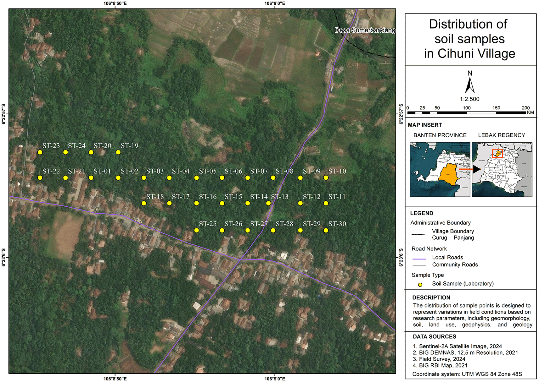
Sampling was carried out around Cihuni Village, Cikulur Sub-district, Lebak Regency, Banten Province. Tests on the physical and mechanical properties of the soil were conducted on 30 soil samples. The sampling method used was the Grid Sampling (Systematic Sampling) method (Harjayanti et al., 2022). The study area was divided into grid plots measuring 50 x 50 m, which served as a reference for determining observation points.
Laboratory testing is carried out to determine the physical and mechanical characteristics of the soil, which form the basis for evaluating slope stability and analysing the susceptibility to landslides. The tests are carried out on soil samples that have been collected previously. Laboratory testing comprises two main groups, namely:
a. Soil physical properties testing
Soil physical property testing is carried out to determine the basic conditions of the soil relating to its ability to absorb and retain water. The parameters analysed include moisture content (ASTM D2216) (ASTM International, 2019) and Atterberg consistency limits (ASTM D4318) (ASTM International, 2017). Water content is used to determine the degree of soil saturation, which influences changes in soil strength (Arsyad et al., 2025). A high water content indicates the potential for an increase in pore water pressure, which can reduce slope stability (Silvianengsih et al., 2015). The Atterberg consistency limits, comprising the liquid limit and the plastic limit, are used to determine the Plasticity Index (PI). The PI value describes the degree of soil plasticity, where a high value generally indicates a predominance of clay soil, which is more susceptible to changes in properties due to increased moisture content (Badan Standardisasi Nasional, 2008; Muhammad Abdul Ghony & Mhd. Dian Afriza2, 2024).
b. Soil mechanical properties testing
Soil mechanical properties testing in this study was carried out using the unconsolidated undrained (UU) triaxial test in accordance with the standard (ASTM D2850) (ASTM International, 2015) to determine the soil shear strength parameters, namely cohesion (c) and internal friction angle (φ).
The cohesion parameter (c) reflects the electrochemical attractive forces between soil particles under undrained conditions (Wiqoyah et al., 2024). Nilai kohesi menjadi indicator ketahanan internal tanah terhadap keruntuhan deformasi. he cohesion value serves as an indicator of the soil’s internal resistance to deformation failure. Meanwhile, the angle of internal friction (φ) describes the internal friction capacity and the interlocking ability between soil particles in resisting slope thrust forces (Haris et al., 2018). Under undrained conditions in clay soils, the internal friction angle tends to be small as it is reduced by the pore water pressure trapped within the pore spaces (void ratio) (Listyawan et al., 2025; Nurdian & Setyanto, 2025).
The laboratory test data were subsequently processed using statistical analysis methods. Tests for data distribution and normality were conducted using descriptive statistical methods, specifically histogram visualisations and quantile-quantile plots (Q-Q plots). This analysis was carried out on all soil parameters to validate whether the field data distribution was representative and met the assumptions of a normal distribution (Suradi, 2014). Then, correlation analysis was carried out using scatter plots to evaluate the interrelationship between specific parameters. The focus of the correlation was on the influence of physical properties on soil mechanics. The strength of the linear relationship was measured using the coefficient of determination (R2) (Abdillah et al., 2021).
Using the grid sampling approach, the study area in Cihuni Village was divided into blocks measuring 50 x 50 m. A total of 30 sampling points were identified, distributed throughout the study area. Soil samples were taken at a shallow depth of 0–1 m, which corresponds to the active weathering zone of the Bojong Formation rocks and is also the top layer most susceptible to saturation due to direct rainwater infiltration. The spatial distribution of the samples is shown in Figure 1.
The samples collected were subsequently tested in the laboratory to determine their physical and mechanical properties. The results of the laboratory tests on these 30 residual soil samples are presented in full in Table 1.
a. Results of soil physical properties tests
Table 2 summarises data on soil physical properties, including the natural moisture content (w) and plasticity index (PI) obtained from the Atterberg consistency limits. These data reflect the soil’s initial hydraulic conditions and the material’s sensitivity to water.
b. Results of soil mechanical properties tests
Table 3 presents the soil shear strength parameters obtained from unconsolidated undrained (UU) triaxial tests, namely the cohesion (c) and internal friction angle. These mechanical parameters represent the soil’s internal resistance to shear stress under undrained conditions.
a. Distribution and normality of soil parameter data
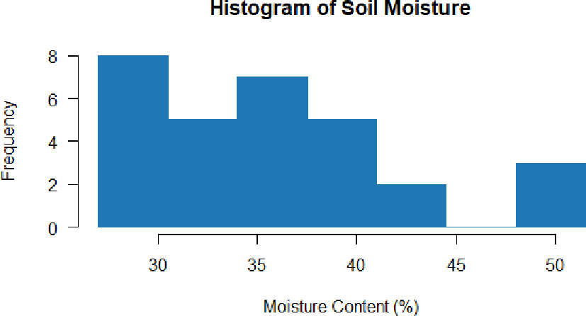
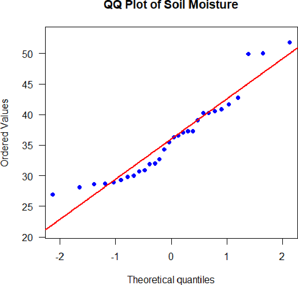
The histogram in Figure 2 shows that the soil moisture content data exhibits a right-skewed distribution (positive skewness), with the majority of samples falling within the 27% – 30% range. Nevertheless, the results of the Q-Q plot in Figure 3 indicate that the majority of data points still follow and align with the diagonal reference line. Minor deviations are only found at the extremes of the distribution (very low and very high moisture content). Overall, this distribution of soil moisture content data is considered sufficiently representative and close to the assumption of a normal distribution.
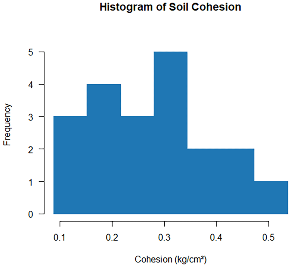
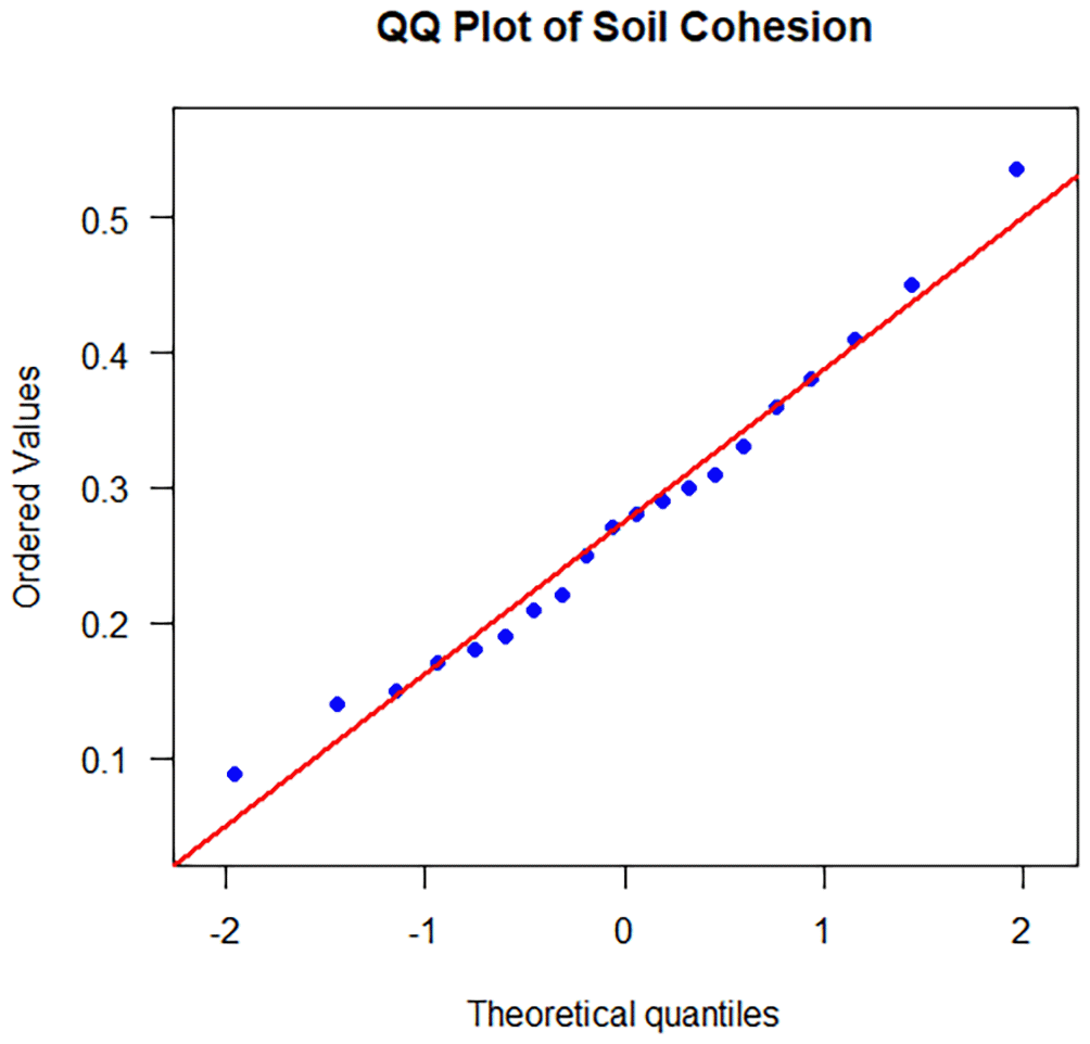
The histogram in Figure 4 shows that the distribution of soil cohesion tends to be symmetrical (bell-shaped), with the highest frequency values occurring in the range of 0.28 kg/cm2–0.34 kg/cm2. This characteristic is reinforced by the Q-Q plot in Figure 5, where all data points in the linear distribution consistently lie on the diagonal reference line without showing any significant deviation at either end of the extreme values. This visually confirms that the soil cohesion parameter data ideally satisfy the assumptions of a normal distribution.
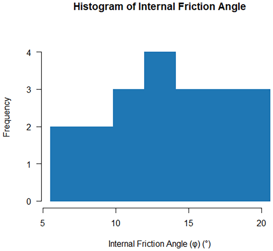
The histogram in Figure 6 shows fairly even values across the entire sample range, with the highest frequency peak occurring at values between 12° and 14°. The interpretation of the Q-Q plot in Figure 7 confirms the accuracy, as all observed data points align linearly and precisely along the theoretical line. The consistency of the data point distribution in the Q-Q plot confirms that the internal friction angle parameter exhibits data characteristics that satisfy the assumptions of a normal distribution.
b. Relationships between soil parameters

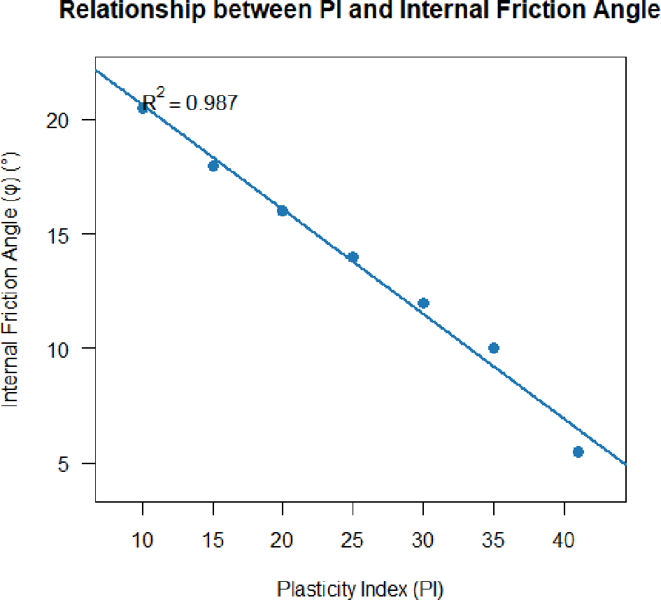
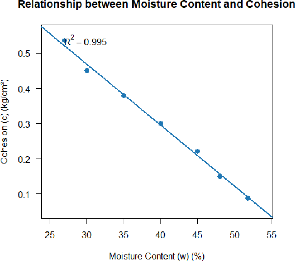
An analysis of the relationships between soil parameters was carried out to understand the interrelationships between the physical and mechanical properties of soil, particularly in relation to slope stability. To determine the effect of plasticity on soil shear strength, an analysis of the relationship between the plasticity index (PI) and the internal friction angle (φ) was carried out. In addition, an analysis of the relationship between moisture content and soil cohesion (c) was also conducted. The results of the data plots and trends of these relationships are described as follows:
1. The Relationship Between the Plasticity Index (PI) and the Internal Fraction Angle
Based on the analysis results in Figure 8, there is a very clear negative correlation or inverse relationship between the plasticity index (PI) and the internal friction angle (φ). An increase in the PI value from 10 to 41 is accompanied by a consistent decrease in the internal friction angle from approximately 20.5° to a minimum value of 5.5°. The coefficient of determination (R2) of 0.987 indicates a strong mechanical relationship, whereby the higher the plasticity of the soil, the greater the reduction in frictional bonds or friction between particles within the soil mass, thereby reducing the internal friction strength (Miranda Hutabarat & Widjaja, 2020).
2. The Relationship Between Soil Moisture and Cohesion
Based on the analysis in Figure 9, a negative correlation trend was observed, with soil moisture content increasing from 27% to 52%. The soil cohesion value decreased drastically in a linear fashion from a maximum of 0.53 kg/cm2 to 0.09 kg/cm2. This phenomenon indicates that the ingress of water into soil pores reduces effective stress and widens the spacing between clay particles, thereby disrupting the electrochemical bonds that form cohesion and directly reducing the soil’s shear strength in resisting slope loads (Utami & Caroline, 2018).
The physical and mechanical characteristics of the residual soil obtained from laboratory tests reflect the strong influence of regional geological conditions and geomorphological factors in the village of Curug Panjang. Litologically, the study site is characterised by the Bojong Formation (Qpb), which is dominated by sandy napal, sandy clay, and tuffaceous sandstone (Rusmana et al., 1991). Under tropical climatic conditions, this Pleistocene rock formation has undergone very intense biochemical weathering, resulting in a thick layer of weathered soil (residual soil) rich in clay fractions (Departemen Permukiman dan Prasarana Wilayah, 2002). This material is inherently much weaker, has low shear strength, and is highly susceptible to deformation compared to its parent rock (Das & Sobhan, 2018). This heterogeneity in the degree of weathering and local water infiltration is confirmed by variations in the natural moisture content data (27% – 52%). The high void ratio values in some samples indicate a relatively loose soil pore structure (Idrus & Suparman, 2015). This zone of sparse porosity acts as a natural drainage pathway that facilitates rapid surface water infiltration during heavy rainfall, which in turn initiates local water saturation within the slope soil mass. This accumulation phenomenon, resulting from variations in porosity during weathering, is consistent with the findings of (Zhang et al., 2024) and (Teixeira et al., 2011) which state that rainwater infiltration into loosely porous residual soil exponentially accelerates slope saturation and reduces its internal stability.
From a geomorphological perspective, the risk of landslides is exacerbated by the topographical conditions of the terrain. According to the classification (Van Zuidam, 1985), the ‘Moderately Steep–Steep’ geomorphological unit (slope angle 8°–35°) accounts for 22.33% of the total area. Steep hillsides exert a much greater gravitational force on the soil mass than flat, gentle slopes (Mulyaningsih, 2018; Darmawan & Hutama, 2025). The thick layer of residual soil on the steep slope remains in a critical condition, as the increased weight of the soil when wet will multiply the force driving the landslide (Panitia Teknis Bahan Konstruksi Bangunan dan Rekayasa Sipil, 2005). This situation is exacerbated by the presence of a sandy clay layer from the Bojong Formation, which has very low permeability, beneath the surface layer. Due to the contrasting permeability, water infiltrating the soil is trapped and accumulates at the interface between the layers. This process creates massive pore water pressure and also forms a weak zone that acts as a potential slip surface beneath the Cihuni Village slope. The accumulation of water at the contact boundary between layers of differing permeability is the triggering mechanism for landslides in weathered soil, as explained in the study (Rahardjo et al., 2008) and (Ullah, 2021) in cases of landslides in Indonesia’s critical slope areas.
The clay soils of the Bojong Formation have a high plasticity index (PI) (reaching a value of 41), indicating extreme sensitivity to water. This high plasticity characteristic reduces the internal friction angle to just 5.5°, meaning the ability of soil particles to interlock and resist friction is almost entirely lost (Haris et al., 2018). The inverse relationship between PI and the angle of internal friction replicates the findings of a global study by (Purnomo, 2011) which confirms that soils dominated by active clay minerals (high PI) will experience a drastic reduction in the angle of internal friction due to water lubrication on the surfaces of flat clay particles.
According to the Mohr-Coulomb failure criteria, the extreme decline in these two mechanical parameters (cohesion and internal friction angle) under water-saturated conditions leads to a complete degradation of the soil’s total shear strength (s) (Sukandi & Malikah Hr, 2021). It is this drastic reduction in the internal shear strength required to support the slope load that provides the scientific explanation behind the massive landslide disaster in early 2022 in Kampung Cihuni, which destroyed dozens of homes and road infrastructure. This research demonstrates that the susceptibility to landslides in the study area is not solely controlled by external factors such as slope gradient and rainfall, but is critically influenced by the internal weakening of the residual soil’s physical and mechanical properties.
Based on the results of laboratory testing, statistical analysis and the discussion conducted, this study has successfully confirmed the engineering characteristics of the residual soil in Kampung Cihuni, Curug Panjang Village, along with the scientific mechanisms underlying its susceptibility to landslides. Distribution analysis using descriptive statistics demonstrated that the parameters of moisture content, cohesion, and angle of internal friction strongly and ideally met the assumptions of a normal distribution, as evidenced by histograms and Q-Q plots, whilst the void ratio parameter exhibited a right-skewed distribution, reflecting the heterogeneity in soil mass density in the field.
The correlation analysis further revealed a very strong negative linear relationship between the parameters, whereby an increase in the plasticity index (PI) reduced the internal friction angle (φ) to a minimum of 5.5° (R2 = 0.987), and an increase in natural moisture content drastically reduces the soil cohesion (c) from 0.53 kg/cm2 to just 0.09 kg/cm2 (R2 = 0.995).
This phenomenon demonstrates that the infiltration of rainwater into the loose residual soil pores of the Bojong Formation triggers water saturation, increases pore water pressure, and breaks down the electrochemical cohesive bonds between clay particles. The extreme decline in these cohesion and internal friction angle parameters caused the total shear strength of the soil to plummet to a level below the shear stress due to gravitational forces on slopes ranging from moderately steep to steep (8° – 35°). It was this internal failure of the residual soil material that was the primary controlling factor in the occurrence of the massive landslide disaster in early 2022 in the study area.
Ethics approval is not required as this study focuses on laboratory test data from soil samples.
During the preparation of this work, the authors utilized Google Gemini (Large Language Model) to assist with language editing, structuring, and formatting the manuscript to adhere to journal guidelines. After using this tool/service, the authors reviewed and edited the content as needed and take full responsibility for the accuracy and originality of the publication.
The authors would like to express their highest gratitude to the Indonesia Endowment Fund for Education (Lembaga Pengelola Dana Pendidikan/LPDP) for the financial support provided during this academic journey. The authors also sincerely thank the Engineering Geology Laboratory, Universitas Padjadjaran for providing the laboratory facilities and technical support during the soil testing phase.
This publication was supported by the Indonesia Endowment Fund for Education Agency (Lembaga Pengelola Dana Pendidikan/LPDP). The funders had no role in study design, data collection and analysis the decision to publish or preparation of the manuscript.
The funders had no role in study design, data collection and analysis, decision to publish, or preparation of the manuscript.
© 2026 Syafri A et al. This is an open access article distributed under the terms of the Creative Commons Attribution License, which permits unrestricted use, distribution, and reproduction in any medium, provided the original work is properly cited.
Current Reviewer Status:
AWAITING PEER REVIEW
AWAITING PEER REVIEW
?
Key to Reviewer Statuses VIEW HIDE
ApprovedThe paper is scientifically sound in its current form and only minor, if any, improvements are suggested
Approved with reservations A number of small changes, sometimes more significant revisions are required to address specific details and improve the papers academic merit.
Not approvedFundamental flaws in the paper seriously undermine the findings and conclusions