Просмотр новости
Найдите то, что Вас интересует
 Спутники
 РН
РН SpaceX
 Роскосмос
 NASA
NASA
СпутникиРНSpaceXРоскосмосNASAAccording to the National Weather Service Missoula Office, rain over the weekend brought more rain to the areas around Glacier National Park, the Bitterroot Mountains and the Flint Creek range than they normally get in a month or two. Continue reading…
Laura Lundquist
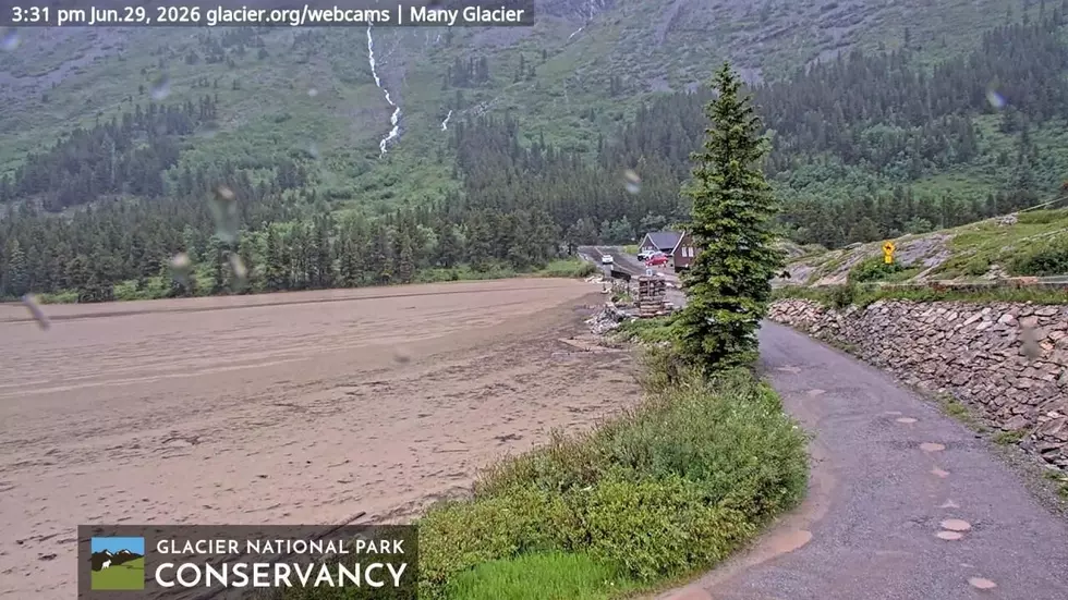
(Missoula Current) Due to sudden flooding, Glacier National Park has evacuated and closed several visitor sites temporarily in the Many Glacier area.
While much of the nation is suffering through extreme heat, a recent weather system brought cooler temperatures and significant moisture to western Montana. While anglers and farmers were happy, some areas got a little more rain than they needed.
According to the National Weather Service Missoula Office, the weekend brought more rain to the areas around Glacier National Park, the Bitterroot Mountains and the Flint Creek range than they normally get in a month or two.
Glacier National Park received 2.2 to 3.2 inches over the weekend, prompting streams to surge and lakes to rise. On Monday morning, the National Weather Service issued a flood watch for the West Glacier region and the Flathead-Mission valleys that extends through Tuesday evening.
Streams began to overflow their banks. By midday, the Swiftcurrent Pass Trail and the Swiftcurrent Motor Inn parking lot and campground were filling with water. Social media posts showed water levels rising in Lake Sherbourne near Many Glacier Lodge to where the water flowing toward the Sherbourne Dam was barely below the bridge leading to the lodge.
The Sherbourne Dam was opened to full release to drop lake levels. The last time the dam was fully open was 1972, according to park rangers. The owner of the Two Sisters Cafe in Babb said in a social media post that the Swiftcurrent Creek below the dam was the highest she’d seen it in 34 years.
By 6 p.m. Monday, park managers made the call to evacuate and close sites throughout the Many Glacier Valley, including Many Glacier Hotel, Swiftcurrent Motor Inn, and the Many Glacier Campground. Trails in the area are also closed and commercial boat tours are suspended.
Glacier National Park said in a press release that it will work closely with the Federal Highway Administration when it is time to reopen the Many Glacier Valley to ensure that access is restored safely.
Glacier Park had already closed the upper Going-to-the-Sun Highway on Sunday due to rain and snow forecasts. The road is now closed from Avalanche on the west side to Rising Sun on the east side.
The National Weather Service issued a Prolonged Rain and Runoff warning from through Tuesday. Heavy rain in steep terrain may lead to possible rockslides, and rapid water rises from small streams.
River levels are rising on the west side of the park too. The flow in the Middle Fork of the Flathead River near West Glacier has almost doubled in two days, carrying large logs and other debris with it. Organizations such as the Flathead River Alliance are cautioning boaters to check conditions before they head out on the river.
To the south, the higher terrain of the Mission and Swan ranges received 2 to 5 inches of rain over the weekend, with an additional 1 to 3 inches predicted. Some flooding was reported Monday in Ronan.
Farther south, the Flint Creek Range southeast of Missoula and the Bitterroot Mountains above Lake Como received more than 2 inches over the weekend. Discovery Ski Area received more than 8 inches of new snow and over in the Bozeman area, Bridger Bowl and Big Sky Resort also received several inches. The Beartooth Highway outside of Red Lodge also closed Monday due to “extreme travel conditions.”
Missoula itself has received almost 1.5 inches of rain as of Tuesday morning.
Contact reporter Laura Lundquist at lundquist@missoulacurrent.com.
| # | Наименование новости | Тональность | Информативность | Дата публикации |
|---|---|---|---|---|
| 1 | Власти пострадавшего от паводка Забайкалья определят места для строительства новых дамб | 0 | 0 | 25-12-2018 |
| 2 | Missouri Flooding Leaves One Dead, Forces Evacuation of Summer Camp | -3 | 6 | 13-07-2026 |
| 3 | More than 200 people at a summer camp helicoptered to safety as Missouri faces flooding | -1 | 7 | 11-07-2026 |
| 4 | Иркутская ГЭС снижает пропуск воды из-за угрозы подтопления населенных пунктов на Ангаре | 0 | 0 | 17-01-2019 |
| 5 | AWARE: Areas of flooding Sunday morning | 0 | 6 | 28-06-2026 |
| 6 | Gulf State Park Pier closes as Bertha moves through coast | 0 | 3 | 21-07-2026 |
| 7 | В Забайкальском крае на ряде рек повысился уровень воды | 0 | 5 | 27-06-2026 |
| 8 | Сильные дожди и ливни прогнозируют в подтопленных районах Приамурья в середине недели | 0 | 0 | 12-08-2019 |
| 9 | В алтайском селе прорвало дамбу из-за проливных дождей | 0 | 0 | 16-07-2020 |
| 10 | Циклон принес в Приамурье сильные дожди и подтопления | 0 | 0 | 21-07-2019 |